


Weather Miami turns cooler as Florida braces for a breezy late-January dip
Weather Miami is shifting toward a noticeably cooler pattern heading into the final days of January, with a breezy weekend setup that drops overnight temperatures well below what many South Florida residents expect this time of year. Across the broader Florida weather picture, the chill looks sharper inland and north, with several cities forecast to flirt with freezing conditions late Saturday into Sunday.
Miami’s week: mild afternoons, then a sharp weekend cooldown
In Miami, the next few days begin on the mild side with comfortable daytime highs, then pivot toward a cooler, windier weekend. Wednesday, Jan. 28, 2026, is expected to top out in the upper 60s with a low in the low 50s, followed by a warmer Thursday near the low 70s. By Friday, clouds and a couple of showers are possible, but the bigger change arrives late Saturday and Sunday.
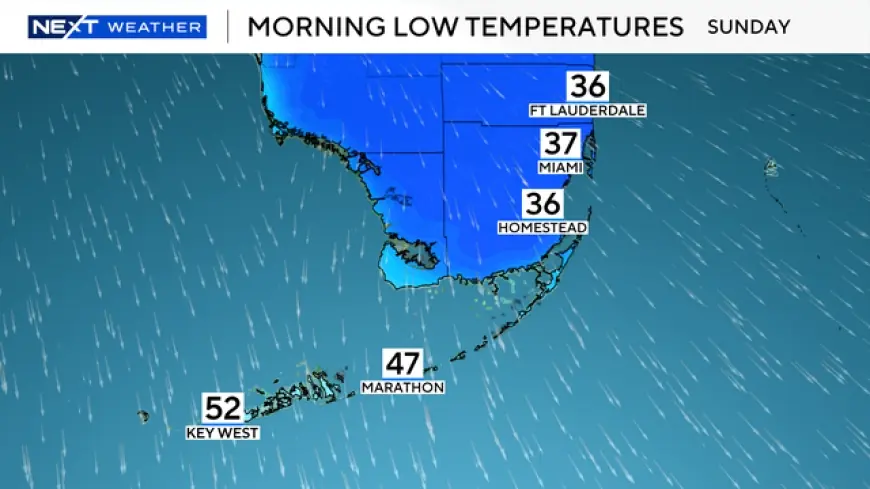
The coldest stretch for Miami is forecast from Saturday night into Sunday morning, when lows dip to around the upper 30s to near 40 degrees, with Sunday afternoon highs only in the mid-50s. Monday stays cool and sunny with highs in the mid-50s, before a gradual rebound Tuesday into the low 60s. Scattered showers remain possible during the transition, but the headline is the temperature drop and the wind that can make it feel cooler, especially near the water.
Further specifics were not immediately available on how sharp the temperature difference will be neighborhood by neighborhood, a common challenge in South Florida where ocean influence can keep coastal readings higher than inland spots.
Florida weather snapshot: colder north and inland, less extreme in the Keys
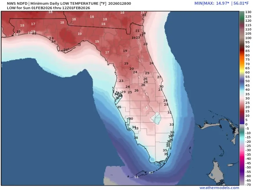
The same pattern looks more intense away from the coast and farther north. Orlando is forecast to slide from highs in the 60s and 70s late week to a weekend high near the upper 50s, with lows dropping into the mid-20s late Saturday. Tampa also cools notably, with weekend highs in the upper 50s and lows near the low 30s.
Jacksonville and Tallahassee show the sharpest bite in the forecast. Jacksonville is projected to fall into the mid-20s late Saturday with a Sunday high in the mid-40s. Tallahassee could dip near 20 degrees late Saturday, then remain cold and breezy into Sunday. Those numbers put much of North Florida firmly in winter mode, even if the cool spell is brief.
Farther south, the Florida Keys look less extreme but still cooler than normal. Key West is forecast to hold in the upper 60s to low 70s for highs most days, with a cooler push late weekend bringing highs closer to the upper 50s and lows in the low to mid-50s.
Some specifics have not been publicly clarified, including whether winds will reach advisory-level thresholds in the most exposed coastal corridors during the weekend.
Why the temperature drop can happen fast in Florida
This kind of quick swing typically follows a frontal passage, when cooler, drier air pushes southward behind a boundary and winds increase as pressure differences tighten. Once the cooler air arrives, nighttime temperatures can fall rapidly, especially inland where there’s less ocean moderation. Clearer skies and lighter winds overnight can also allow heat to escape more efficiently, a process that makes lows drop faster than many people expect after a warm afternoon.
Even when daytime sunshine returns quickly, the air mass itself can stay cool for a day or two. That is why Florida can see sunny conditions at the same time residents notice jackets at the bus stop and a chill inside homes that are not built for prolonged cold.
Who feels it most, and the next key update window
Two groups feel these shifts first: commuters and school families dealing with colder early mornings, and outdoor workers who spend long stretches in the wind. Boaters and beachgoers also face a double impact, as breeze plus lower temperatures can make conditions feel substantially cooler than the thermometer suggests.
There’s also a practical ripple for vulnerable residents and people without reliable heating, as well as for growers in colder pockets of Central and North Florida where near-freezing nights can raise concerns for tender plants. Homeowners may notice higher energy use as heating runs longer overnight, even if the cooldown only lasts a few days.
The next key update window comes Friday afternoon into Friday night ET, when forecasts typically tighten around the weekend temperature floor and the strongest-wind timing, giving a clearer picture of just how low overnight readings could go from late Saturday into Sunday morning.