


Upcoming Days Bring Hazardous Icy Road Conditions
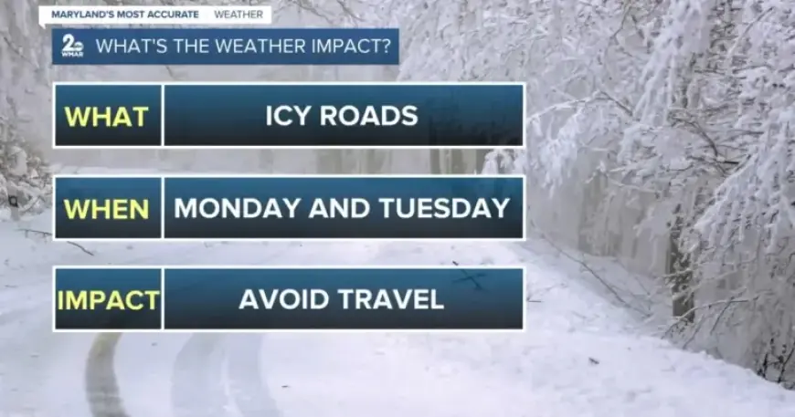
As winter weather progresses, hazardous icy road conditions are expected to persist in the coming days. With an impending storm moving away from the Baltimore region, extreme cold will continue to challenge drivers and pedestrians alike.
Current Weather Conditions
Roads will remain slick, particularly on bridges and overpasses. The onset of Monday will bring cloudy skies, but the sun is expected to shine by the afternoon. Wind gusts may exceed 25 mph, adding to the chill.
Temperature Forecast
The week ahead will be marked by dry, sunny conditions. However, temperatures are projected to drop significantly, especially towards Friday:
- Monday: Mostly sunny, high near 29°F.
- Monday Night: Mostly clear, low around 6°F.
- Tuesday: Sunny, high near 23°F.
- Tuesday Night: Partly cloudy, low around 7°F.
- Wednesday: Mostly sunny, high near 24°F.
- Wednesday Night: Mostly cloudy, low around 10°F.
- Thursday: Partly sunny, high near 23°F.
- Thursday Night: Mostly clear, low around 7°F.
- Friday: Mostly sunny, high near 22°F.
- Friday Night: Mostly clear, low around 10°F.
- Saturday: Mostly sunny, high near 26°F.
Safety Measures
With temperatures expected to fall into the single digits, wind chills could feel as frigid as -10°F. Residents should take precautions to protect plumbing. It’s advisable to keep faucets dripping overnight to prevent pipes from freezing.
Stay safe and warm during these icy conditions as the cold snap continues throughout the week.