


Boston Snowfall Forecast: Detailed Look at This Weekend’s Massachusetts Weather
A significant winter storm is set to impact Massachusetts from Sunday into Monday, bringing snow accumulations of 12 to 20 inches across most regions. This extensive snowfall forecast raises questions about local variances in snowfall amounts. Specific factors will influence the final totals, including sleet, wind patterns, and temperature changes along the coast.
Winter Storm Forecast for Massachusetts
The upcoming storm presents many variables that complicate accurate snowfall predictions. Both sleet and the coastal front will play pivotal roles in determining how much snow areas receive.
Key Regions Affected
- Boston and Surrounding Areas: Expect significant snow, likely in the mid to upper range of 12 to 20 inches. Some locations may even exceed 20 inches, especially with possible snowfall bands rotating through the area.
- South of the Mass. Pike: This region is also projected to receive 12 to 20 inches. However, towns like Taunton and Middleboro could receive less if sleet moves northward.
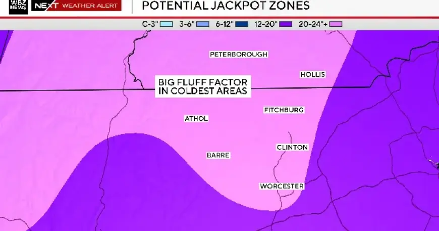
- North of the Pike (Worcester Hills, Route 2): This area is likely to receive the higher end of the snowfall range, with many towns possibly exceeding 20 inches of light, fluffy snow.
- Southeastern Massachusetts, Cape Cod, and Islands: This region poses a challenge due to the potential for sleet. Forecasts suggest snow totals here may be revised downward to between 3 to 6 inches.
Factors Influencing Snowfall
Several meteorological elements will affect snowfall amounts across the state:
- Sleet: This can suppress overall snow accumulation by creating a wet layer that weighs down snowflakes.
- Coastal Front: As temperatures rise overnight, accumulated snow could become heavier, impacting the overall totals.
- Ocean Enhancement: Warm ocean air can generate heavier snowfall bands in coastal towns, creating potential discrepancies in predictions.
This storm represents the potential for both excitement and caution for Massachusetts residents. The National Weather Service and local meteorologists continue to monitor conditions closely to provide updated forecasts as the storm approaches.