


Live Coverage: Icing Conditions Worsen Tonight
As winter conditions worsen, travel impacts are anticipated in South Texas, particularly around San Antonio and the Hill Country. The weather forecast indicates a transition from cold rain to freezing rain tonight, leading to hazardous road conditions.
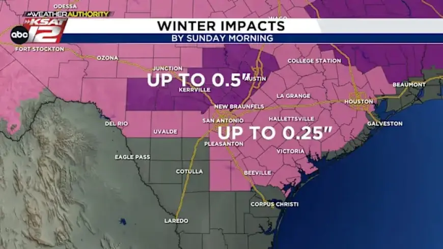
Forecast Overview
From Saturday night into early Sunday morning, areas including Kerr and Kendall counties are expected to witness significant freezing rain and sleet. The National Weather Service predicts up to 0.25 inches of ice accumulation in San Antonio and areas north of I-10. The Hill Country may see as much as 0.5 inches of ice accumulation, while southern counties will likely only experience a light glaze.
Temperature Outlook
Temperatures are projected to remain at or below freezing during the day on Sunday, minimizing any potential melting. Residents should prepare for very cold mornings early next week, as record lows are likely on Monday and Tuesday.
- Expected Conditions:
- Freezing rain continuing through Sunday morning.
- 0.25 inches of ice in San Antonio.
- Up to 0.5 inches of ice in the Hill Country.
- Temperatures remaining below freezing on Sunday.
Future Forecast
As the week progresses, temperatures are expected to rise to the low 60s by the end of the week. Despite the sour conditions currently present, there is a silver lining for residents eagerly anticipating a return to milder weather.
Road Safety Precautions
Authorities recommend using beet juice and saltwater mixtures to maintain road safety during the freeze. Motorists are urged to exercise caution and remain informed about current weather conditions.
As the icy weather unfolds, staying prepared and informed will be crucial. For updates on the weather and travel conditions, visit Filmogaz.com for the latest developments.