


Winter Storm Forecast: Northeast Ohio’s Snowfall Timing Revealed
The upcoming winter storm is set to significantly impact Northeast Ohio this weekend. As it progresses across the United States, the snowfall timeline for the region has become clearer. Fortunately, Saturday appears to be a calm day for residents, providing an opportunity to prepare.
Forecast Overview for Northeast Ohio
The National Weather Service anticipates that snow will begin overnight on Saturday, with accumulating snowfall expected after midnight. Conditions are expected to deteriorate rapidly on Sunday as heavier snow develops throughout the day.
Saturday Conditions
- High temperatures will range from 10 degrees to the lower teens.
- Overnight temperatures will drop into the single digits.
- Daytime roads are anticipated to remain dry, facilitating normal travel.
Timeline for Snowfall
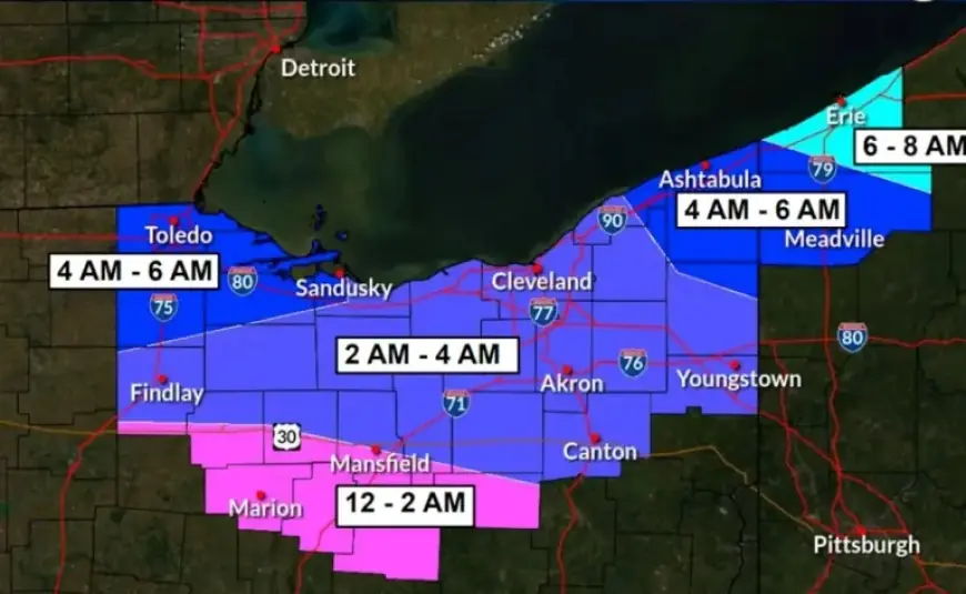
Snowfall will commence from the south, progressing northward through the region. Here’s the breakdown by county:
| Time Frame | Counties Affected |
|---|---|
| 12 a.m. to 2 a.m. | Southern Ashland County, southwestern Wayne County |
| 2 a.m. to 4 a.m. | Lorain, Cuyahoga, Medina, Summit, Stark, Portage, most of Wayne, Geauga, Lake, and Ashland counties |
| 4 a.m. to 6 a.m. | Ashtabula County, northeastern Geauga, and Lake counties |
Initial snowfall may be light on Sunday morning due to dry Arctic air, but conditions will worsen as steadier snow develops.
Significant Impacts Expected on Sunday
Sunday is forecast to be the most impactful day of the storm. Snowfall is likely to intensify, with rates possibly reaching three-quarters of an inch to 1 inch per hour.
- Roads may become slick and snow-covered, impairing visibility and travel.
- Winds are expected to increase to 15 to 25 mph from the northeast, shifting to northwest later.
- Visibility could be reduced to less than a quarter mile during heavy snow.
Travel Advisory
Due to the anticipated hazardous conditions, officials advise residents to postpone non-essential travel on Sunday. For those who must travel, it’s essential to have a winter survival kit, which should include:
- A blanket
- Food and water
- A charged mobile phone
Stranded motorists may face risks from cold exposure as wind chills could drop below zero late Saturday into Sunday morning and again from Sunday night into Monday morning.
Snowfall is expected to persist into Sunday night before gradually tapering off Monday morning from west to east, concluding the winter storm’s impact in Northeast Ohio.