


Alabama Braces for Icy and Snowy Weather
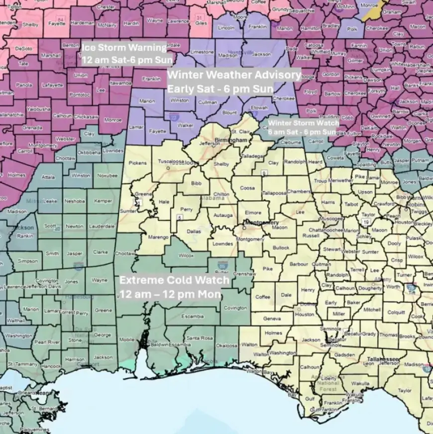
Alabama is preparing for severe winter weather as an ice storm approaches the region. Ice Storm Warnings have been issued for Lauderdale, Colbert, and Franklin counties from 12 a.m. Saturday until 6 p.m. Sunday.
Severe Weather Alerts
Along with Ice Storm Warnings, Winter Weather Advisories and Winter Storm Watches are in effect from early Saturday until 6 p.m. Sunday, particularly north of Interstate 20. Additionally, an Extreme Cold Watch is active for southwestern counties from 12 a.m. to 12 p.m. on Monday.
Forecast Overview
Precipitation is expected to begin in northern Alabama between 2 a.m. and 9 a.m. Saturday. This system will then move southward throughout the day, continuing into Sunday.
- Precipitation will end Sunday evening.
- Snow flurries may linger statewide into Monday morning.
Expected Precipitation
The total precipitation for the northern half of the state is forecast at 2-4 inches of “liquid” totals, with potential localized flooding issues. Southern Alabama may receive around 1-3 inches of total rainfall.
Freezing rain is anticipated to dominate Saturday morning in areas north of I-20, possibly mixing with sleet initially. The far northwestern counties may see ice accumulation of up to 1 inch by Saturday evening. The northeastern counties could receive up to 0.25 inch of ice, while areas south of I-20 are expected to experience less than 0.10 inch of freezing rain.
Impact on Driving Conditions
Driving conditions are expected to be hazardous north of I-20 on Saturday morning and into the afternoon. Temperatures are predicted to rise above freezing later in the day, which should help mitigate ice concerns.
Additional Weather Developments
By Sunday afternoon, a surge of cold air is forecast to push into the northwestern areas, possibly creating conditions for light freezing rain and snow across the northern half of Alabama. Up to 1 inch of snow may accumulate in the far northwest, with trace amounts elsewhere.
The southern half of Alabama could experience showers and thunderstorms, with wind gusts reaching 40-60 mph. Severe weather, including possible tornadoes, is a concern from late Sunday morning to early evening.
Temperature Projections
| Day | Morning Lows | Afternoon Highs |
|---|---|---|
| Monday | Teens to 20s | 20s (North) to 40s (South) |
| Tuesday | Single digits (North) to Teens | Mid-30s (North) to Mid-40s (South) |
By Monday morning, temperatures will likely range from the teens in the northern regions to the low 20s in other areas. Wind chills may be as low as -3 degrees in the north, adding to the chilling effects of the advancing cold front.