


Expect Ice Accumulations Tonight Before Heavy Rain Arrives Sunday Morning
This weekend, the region is under a Storm Alert as a wintry mix transitions to heavy rain. The weather is expected to be particularly volatile, with ice and rain impacting local conditions.
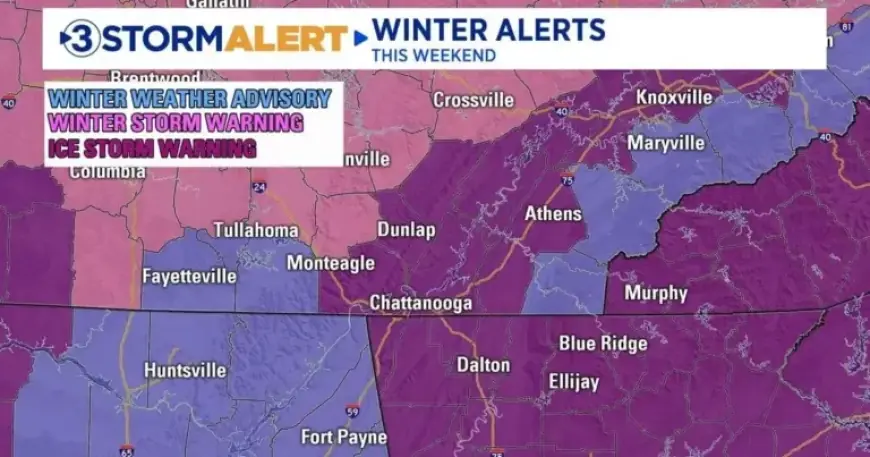
Wintry Mix Forecast: Ice and Snow Accumulations
Between 8 AM and 1 PM today, snow and sleet will likely affect various areas. Light accumulations of up to 0.5 inches are anticipated, particularly on Walden Ridge and the Cumberland Plateau.
Ice Storm Warning
Most of the region is currently under an Ice Storm Warning that extends through Sunday. The critical timeframe for freezing rain accumulations is expected between 7 PM tonight and 3 AM Sunday.
- Temperatures: Close to freezing, with minor fluctuations determining ice versus rain.
- Higher Elevations: Potential ice accumulations up to 0.50 inches.
- Valley Areas: Expect 0.10 to 0.25 inches of ice, though some may only receive rain if temperatures rise above freezing.
- Blue Ridge Mountains: Anticipating ice accumulations of up to 0.25 inches.
Transition to Heavy Rain
Temperatures are forecasted to rise above freezing after midnight on Sunday due to a warm front moving through the Tennessee Valley. This shift will change any remaining icy conditions to cold rain by sunrise or sooner.
Rainfall Accumulation
Rain is expected to persist throughout Sunday, with total accumulations ranging between 1 to 2 inches. The chance of rain will taper off by 7 PM, followed by a drop in temperatures to the teens.
Leftover water on roads may freeze overnight, creating potential slick spots for Monday morning commuters. Stay updated with Filmogaz.com for the latest weather information and safety precautions.