


How many inches of snow this weekend? The answer depends on where you are on a razor-thin storm track
This weekend’s winter storm isn’t just a snow event—it’s a boundary fight between snow, sleet, and freezing rain. That matters because the difference between 3 inches and 18 inches can come down to a subtle shift in the storm’s path or a 1–2°F temperature change in the lowest layer of air. For families, travelers, and utilities, the practical takeaway is that totals will vary sharply over short distances, and the most disruptive impacts may come from ice even where snow looks modest.
The uncertainty is the headline: small shifts, huge changes in totals
Forecasters are increasingly confident a long corridor from the Southern Plains toward the Mid-Atlantic and Northeast sees significant winter weather through the weekend into early Monday. What’s still volatile is where the heaviest snow band sets up—and where it changes over to sleet or freezing rain.
Two features drive the “how many inches” question:
-
Storm track: A northward wobble pulls warmer air in aloft, turning snow into sleet/ice and cutting snow totals. A southward wobble does the opposite.
-
Precipitation type: Snow totals drop quickly if even part of the event falls as sleet or freezing rain. Meanwhile, the same setup can create dangerous ice accretion on the storm’s southern edge.
A slow-moving system increases the ceiling. More hours of precipitation means higher potential totals—if the column stays cold enough for snow.
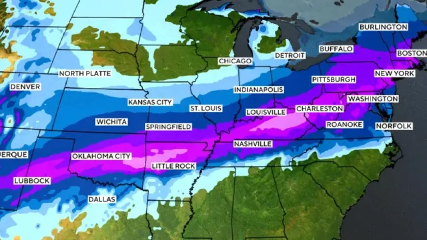
Here’s a practical range guide for Jan. 24–25 (with some areas continuing into early Monday), expressed as broad regional bands rather than a single “national number”:
-
Southern Plains into nearby higher totals zone: Widespread 4–10 inches, with pockets 10–15+ inches where snow stays dominant.
-
Ozarks and parts of the Mid-South into the Ohio/Tennessee valleys: 6–12 inches in the heavier band; lower totals where mixing intrudes.
-
Central Appalachians: A realistic pathway to 12–24 inches where the snow band stalls.
-
Mid-Atlantic into parts of the Northeast: Many areas in the 6–12 inch range, with localized higher totals if the core band tracks overhead.
-
Near the southern edge of the storm: Snow totals can be smaller (often 1–6 inches) because sleet/freezing rain steals accumulation time—even as travel becomes worse.
What’s happening this weekend, and why your town’s number may be wildly different
The storm began laying down precipitation in the Southern Plains and is expected to spread east through Saturday, then reach the Mid-South and portions of the Tennessee/Mississippi valleys, before pushing toward the Mid-Atlantic and Northeast Sunday into Monday. The system’s slow pace is a key reason totals can build.
The biggest “gotcha” is the transition zone—where snow changes to sleet or freezing rain. In that strip, snow totals may look underwhelming on paper, but roads can become nearly unusable. Ice accumulations in the hardest-hit areas can climb toward three-quarters of an inch to around an inch, which is enough to snap limbs and strain power lines—then the cold locks the damage in place.
A few signals that usually separate the jackpot snow band from the “mixed mess” band:
-
Surface temperatures staying below freezing and the air aloft staying cold enough for snow.
-
The storm center passing just far enough south to keep warm air from surging in above ground level.
-
A steady, long-duration precipitation shield rather than a fast-moving burst.
If you’re trying to plan right now, treat these as planning thresholds rather than exact predictions:
-
3 inches: slick roads and reduced visibility, especially with wind and cold pavement.
-
6 inches: plowing becomes necessary; travel disruptions become routine.
-
12 inches: closures become likely, and secondary roads can become impassable.
-
Ice near 0.5 inch+: outage risk climbs quickly, and travel may be worse than during heavier snow.
For the most accurate number, your best move is to follow your local warnings and short-range snowfall forecasts as the storm band locks in. This is the kind of weekend where the “final total” can change fast—and a neighbor 20 miles away may end up in a completely different outcome.