


Nashville weather turns dangerous as snow, ice, and bitter cold spread across Tennessee
Middle Tennessee is heading into a weekend where “inclement weather” stops meaning inconvenience and starts meaning risk: roads that look merely wet can glaze over in minutes, tree limbs can fail under ice weight, and a short power outage can become a health emergency as temperatures plunge. The highest uncertainty isn’t whether winter weather arrives—it’s where the heaviest icing sets up, because small shifts can decide whether a neighborhood gets slushy snow or a half-inch of damaging ice.
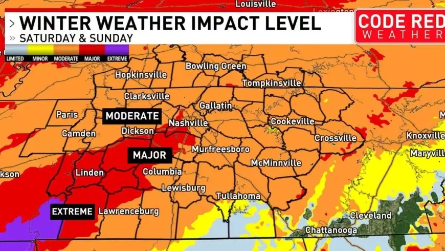
A state on alert as mixed precipitation targets every region
Tennessee entered this stretch under a statewide emergency declaration as forecasts converged on a widespread mix of snow, sleet, and freezing rain followed by dangerous cold. The most immediate concern is the combination that’s toughest to manage: ice on top of snow, which reduces traction, adds weight to power lines, and slows response times even after plows roll.
Across the major metro areas, conditions won’t look identical:
-
Nashville (Middle Tennessee): A winter storm warning is in effect through Sunday evening, with 3–6 inches of snow and sleet and 0.2–0.5 inch of ice possible. Even if totals land on the lower end, the ice component raises the odds of scattered power outages and tree damage.
-
Memphis (West Tennessee): A winter storm warning calls for 3–5 inches of snow and sleet plus 0.2–0.5 inch of ice, with wind gusts that can reach around 35 mph, a combination that can worsen outages where ice loads build.
-
Knoxville (East Tennessee): An ice storm warning points to significant icing (about 0.25–0.5 inch), with lighter snow/sleet totals. That’s the profile that causes the most trouble for lines and limbs—less about drifts, more about weight.
-
Chattanooga (Southeast Tennessee): Also under an ice storm warning, with a similar 0.25–0.5 inch icing potential. Valleys and elevated routes can behave very differently, so travel impacts can vary sharply even within the same county.
The timing is tight: the peak risk window runs Saturday into early Sunday, and then the cleanup becomes more complicated as temperatures plunge, turning slush into concrete and refreezing anything that melts during brief lulls.
The weekend setup, then a hard freeze that lingers
Forecast details show why this is not a “one-and-done” storm. For Nashville, snow is expected to develop Saturday with sleet and freezing rain mixing in later, then lighter snow/ice lingering into Sunday before colder, drier air takes over. Memphis follows a similar track, with wintry mix and periods of freezing rain, then a sharp drop in temperatures.
East Tennessee’s profile is more ice-centric—snow and sleet can start the process, but the more damaging impact is extended glazing that can persist on untreated roads, bridges, and shaded corridors even when precipitation eases.
Then comes the second punch: extreme cold. In Nashville, overnight lows early next week are forecast to dip below zero (Fahrenheit) in spots, with daytime highs struggling in the teens to low 30s. Memphis is also expected to remain well below freezing at night. Knoxville and Chattanooga may rebound slightly sooner, but the refreeze threat remains a daily concern.
A short timeline of the next few days:
-
Saturday (Jan. 24): Snow develops; sleet/freezing rain mixes in across much of the state.
-
Sunday (Jan. 25): Wintry precip tapers; ice remains; travel and power restoration can still be difficult.
-
Monday–Tuesday (Jan. 26–27): Bitter cold increases danger for anyone without reliable heat; refreeze becomes the main hazard.
-
Midweek: Gradual moderation, but shaded ice and piled snow can linger longer than drivers expect.
Publicly shared posts have also put high-profile meteorologist Jim Cantore in Nashville during the lead-up, reflecting how widely this system is being watched—though the practical reality is the same regardless of who’s on the sidewalk: mixed precipitation and rapid temperature swings are the most disruptive combination Tennessee sees.
For residents, the most useful mindset is to treat this as two events: a snow/ice storm that can isolate neighborhoods, followed by a cold spell that can turn a routine outage into a serious situation. In that gap—between the last flakes and the first deep freeze—small preparations (heat backup plans, charged devices, stocked water, and staying off roads when ice is present) can matter more than any radar image.


