


NYC Winter Storm: Sunday’s Expected Snowfall in Inches
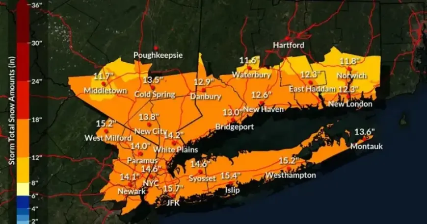
A significant winter storm is forecast to impact New York City this weekend, bringing the possibility of up to 16 inches of snow. The National Weather Service (NWS) anticipates that the storm will develop late Saturday night and extend into Monday, resulting in significant snow accumulation and extremely cold temperatures.
Snowfall Predictions for NYC
According to the NWS, there is over an 85% probability of receiving at least six inches of snow across the region, with a steady 50% chance for totals exceeding 12 inches. Heavy snowfall is expected primarily on Sunday, leading to potential disruptions in travel.
Timeline of the Winter Storm
Snow is likely to begin falling as early as Saturday night, continuing through Monday afternoon. The period of heaviest snowfall is anticipated on Sunday into the evening, which could result in swift accumulation and hazardous travel conditions.
- Saturday Night: Snow begins after 1 a.m.
- Sunday: Expected high of 23°F, with snowfall rates increasing.
- Monday: Snow may taper off, but cold conditions persist.
Cold Weather Ahead
Following the storm, residents should brace for a prolonged period of frigid temperatures that will persist into the middle of next week. Daytime highs will struggle to remain above freezing, with overnight lows dipping significantly. Wind chills could drop to subzero levels, raising concerns about infrastructure like frozen pipes and increased heating demands.
Potential Impact of Mixing Precipitation
Currently, forecasters predict that most of the snow will be dry and powdery, which can lead to quick accumulation. However, there remains a slight chance for a wintry mix, particularly in southern areas of the tri-state region, if the storm shifts closer to the coast Sunday evening.
Preparation Advice
The NWS advises residents to prepare for significant winter weather. Monitoring updates as the storm approaches is crucial, given the inherent uncertainty regarding exact snowfall totals and potential mixing of precipitation. The ongoing monitoring of the polar vortex—an area of low pressure typically located over the Arctic—could also influence the storm’s impact.
For ongoing coverage and expert weather forecasts, visit Filmogaz.com for real-time updates as this winter storm approaches New York City.