


Winter Storm Watch: Why the “Watch” Matters More Than the Snow Totals Right Now
A winter storm watch is less about what has already happened and more about what could change quickly—especially when the exact mix of snow, sleet, and freezing rain is still uncertain. In several areas under watch in the U.S. heading into the January 24–26 weekend window, the biggest risk isn’t just accumulation; it’s timing, ice potential, and the knock-on effects: dangerous travel, scattered power outages, and the kind of cold that turns small household issues (like weak pipes or dead car batteries) into urgent problems.
The Real Risk in a Winter Storm Watch: Uncertainty + Compounding Impacts
A “watch” is issued when conditions are becoming favorable for significant winter weather, but key details are still in flux—storm track shifts, temperature profiles, and how long precipitation lingers. That uncertainty matters because it widens the range of outcomes:
-
A small temperature change can turn a plowable snow into a glaze of ice.
-
A slight track wobble can shift the heaviest band from one metro area to another.
-
A faster arrival can catch commuters and crews unprepared; a slower one can extend impacts into a second day.
What elevates a winter storm watch beyond routine winter weather is the potential for disruption: hazardous roads, reduced visibility, and the possibility of power interruptions—especially in places where freezing rain becomes a primary concern. Even if snowfall totals end up modest, ice and wind can make conditions worse than the numbers suggest.
Where Watches Are Being Issued and What’s Being Watched Closely
Across multiple regions, winter storm watches have been posted for a weekend system that may spread snow and ice over a wide swath of the country. The watch area includes parts of the South, Midwest, and Northeast, with different hazards emphasized in different zones.
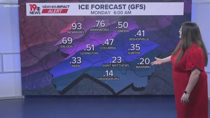
In parts of Texas, the watch focus includes mixed precipitation and icing risk—conditions that can quickly create impassable bridges and ramps, while also stressing power lines and tree limbs. Farther north and west into portions of the Midwest near the St. Louis region, watches highlight the potential for plowable snow alongside very low temperatures and dangerous wind chills. In New York state, the watch messaging centers on the possibility of heavier snow bands, which can create rapid changes in road conditions over short distances.
The broader setup being monitored is a storm capable of producing different “types” of winter impact along its path: heavier snow on the colder side, more sleet/freezing rain in the transition zone, and a sharp drop in temperatures behind the system that can cause a flash-freeze if roads are wet.
Practical takeaway: the most disruptive outcomes often occur near the rain–ice–snow boundary, where forecasts can change most in the final 12–24 hours.
What This Means Next
In the short term, expect watch areas to see higher-confidence refinements: tighter timing, more specific snow/ice ranges, and—in some places—upgrades from “watch” to warning or advisory as confidence increases. That transition is the signal to move from “prepare” to “act.”
Who benefits and who loses (in practical terms):
-
Benefiting: areas with well-resourced road treatment crews and residents who can adjust travel plans early; businesses with flexible scheduling.
-
Losing: communities in the potential ice corridor, where even light icing can trigger outages; travelers on tight itineraries; people without reliable heat, winter clothing, or transportation; drivers during overnight-to-morning transitions when refreezing is common.
What to watch next over the next day:
-
Precipitation type forecast (snow vs sleet vs freezing rain), not just totals.
-
Temperature trend at the surface—a 1–2°F difference can flip outcomes.
-
Start time vs commute windows in your area.
-
Wind and “flash freeze” risk after precipitation ends.
-
Alert upgrades (watch → warning/advisory) from local weather offices.
If you’re in or near a winter storm watch, the best move is to plan for the higher-impact scenario—especially if ice is possible—while staying ready for forecast shifts. That means charging devices, checking heat sources, avoiding unnecessary travel during peak timing, and treating bridges/overpasses as the first places that can become dangerous.