


Winter Storm This Weekend: Snow, Ice, and a Deep Freeze Set to Disrupt Travel Across a Broad U.S. Swath
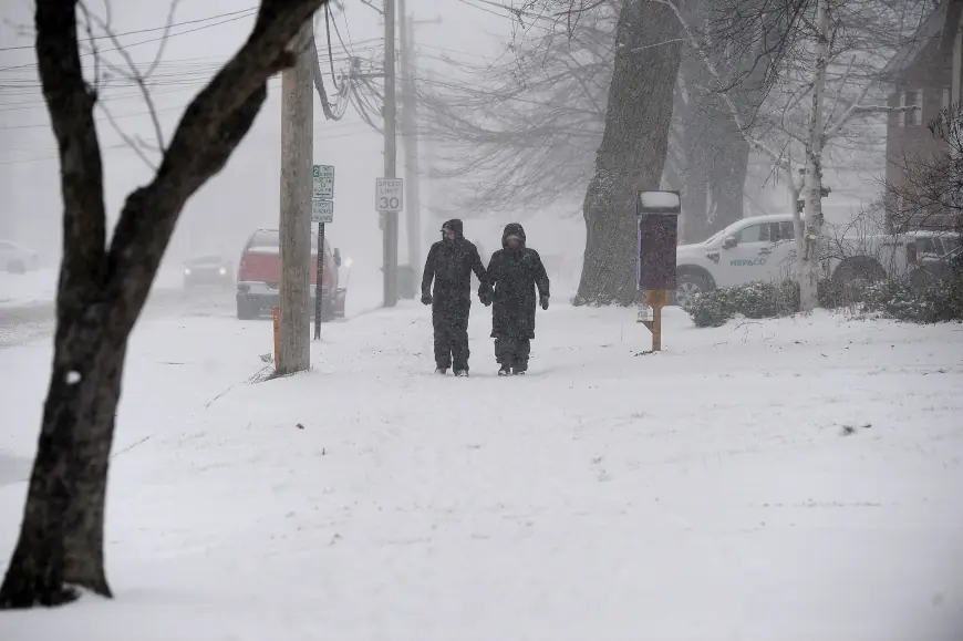
A fast-evolving winter storm this weekend is shaping up to deliver a messy mix of heavy snow, sleet, and freezing rain across large portions of the United States from Saturday night, January 24, into Monday, January 26. The biggest concern isn’t just snowfall totals—it’s the overlap of snow with significant icing potential, followed by a surge of Arctic air that can keep roads hazardous and strain power systems well after the last flakes fall.
Forecast confidence is growing that millions of people will see impactful winter weather, but the precise storm track still matters. A shift of even 50–100 miles can flip an area from “mostly snow” to “mostly ice,” changing the risk from plowable snow to power-line and tree damage.
Where the winter storm this weekend is most likely to hit
While impacts will vary by region, the storm’s footprint is expected to stretch from the southern Plains and lower Mississippi Valley through parts of the Ohio and Tennessee valleys, then into the Mid-Atlantic and New England.
Areas most likely to see significant impacts include:
-
Interior Mid-Atlantic and parts of the I-95 corridor: Snow changing to sleet/freezing rain in some spots, with difficult travel windows overnight Saturday into Sunday.
-
Ohio Valley and central Appalachians: Several inches of snow possible, with bitter wind chills and slick secondary roads.
-
The Carolinas and portions of the Southeast: Higher odds of freezing rain and sleet—often the most disruptive scenario for power and trees.
-
New England: A scenario exists for heavy, accumulating snow, especially if colder air locks in early.
Local winter storm watches are already being posted in multiple regions, signaling that significant accumulations and dangerous travel are plausible within the next 48–72 hours.
Snow vs. ice: why the “changeover line” matters
The storm is expected to pull moist air northward over shallow cold air near the ground. That setup creates a classic winter-weather battleground:
-
Colder side of the storm: Mostly snow, with periods of heavy snowfall and reduced visibility.
-
Transition zone: Sleet and a snow/sleet mix that compacts into a hard, slippery layer.
-
Warmer aloft but freezing at the surface: Freezing rain—often the worst outcome for trees, lines, and untreated roads.
In parts of the Mid-Atlantic and the Southeast, the primary risk may be ice accretion rather than snow depth. Even a thin glaze can create widespread crashes and cause scattered power outages. If ice totals creep higher, outages can become more extensive.
Timeline: when conditions could deteriorate
Timing will differ by city, but here’s a practical planning window for many communities:
| Period (ET) | What to expect |
|---|---|
| Friday night, Jan 23 | Colder air strengthens; early advisories and pretreating ramps up |
| Saturday daytime, Jan 24 | Clouds thicken; first precipitation develops in some areas |
| Saturday night–Sunday, Jan 24–25 | Peak impacts: heavy snow bands and/or freezing rain; worst travel |
| Sunday night, Jan 25 | Precip tapers in many places; flash-freeze risk rises |
| Monday, Jan 26 | Lingering slick spots; Arctic air keeps untreated surfaces hazardous |
The most dangerous travel period is likely overnight Saturday into midday Sunday in many areas—especially where the precipitation type changes.
Travel disruption and power-outage potential
Air and road travel may take a hit this weekend, particularly near major hubs where ice is involved. Even if runways are cleared, de-icing operations and staffing constraints can cascade into delays and cancellations. On highways, the bigger concern is the combination of overnight precipitation with low temperatures that prevent melting.
Power-outage risk rises sharply in areas expecting freezing rain and gusty winds. If branches and lines accumulate ice, crews may face difficult access on untreated roads—slowing restoration.
Practical impacts to anticipate:
-
Sudden road closures from multi-vehicle pileups
-
Reduced emergency response times
-
School and event cancellations extending into Monday in harder-hit zones
-
Local shortages of road salt and de-icing supplies
Arctic air after the storm: the “second punch”
Behind the storm, a push of bitterly cold air is expected to settle in, keeping daytime highs suppressed and nighttime lows very low across parts of the central and eastern U.S. That matters because it:
-
Locks in icy conditions on shaded and secondary roads
-
Increases the risk of flash-freezing when precipitation ends
-
Raises the chance of burst pipes and heating-system strain
-
Elevates health risks for vulnerable populations and anyone without stable heat
How to prepare now (before the first flakes)
If you’re anywhere in the potential impact zone, a few moves help regardless of whether you get more snow or more ice:
-
Avoid “must-drive” plans Saturday night through Sunday if possible.
-
Charge devices and set aside battery packs; prepare for outages in ice-prone areas.
-
Stock essentials for 48 hours: water, easy meals, meds, pet supplies.
-
Protect plumbing: insulate exposed pipes, let faucets drip if temperatures plunge.
-
Vehicle basics: full tank, windshield fluid rated for low temps, blanket, shovel.
-
Know your alerts: winter storm watches may upgrade to warnings as confidence increases.
What to watch next as forecasts update
The most important forecast details over the next day:
-
Where the heaviest snow band sets up
-
The location of the freezing rain corridor
-
How quickly the storm exits and whether a flash-freeze becomes widespread
-
Any last-minute track shift that changes totals dramatically
Recent updates indicate a high-impact winter storm this weekend is increasingly likely; finer details may still evolve, especially near the rain/snow/ice boundary.