


Weather Forecast Snow Storm: Expansive Winter System Spreads Heavy Snow, Ice, and Dangerous Cold Across the U.S.
A high-impact winter system is taking shape across a broad slice of the United States, with the weather forecast pointing to a multi-day snow storm threat that also includes significant icing and a renewed surge of bitter cold. The latest outlooks show the storm’s track continuing to wobble, which is shifting the sharp line between heavy snow and freezing rain—an important detail that can drastically change travel conditions, power-outage risk, and road safety within just a county or two.
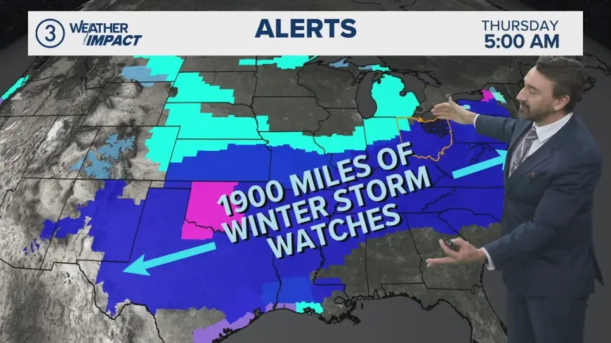
While snowfall totals and exact ice amounts will be refined as the storm evolves, the overall message is consistent: a wide corridor from the Southwest through parts of the Plains and Midwest, then into the South, Appalachians, and portions of the Northeast is facing a period of disruptive winter weather.
Where the weather forecast snow storm is headed next
This is not a “one-city” event. The storm’s footprint is expansive, and the biggest impacts will depend on where colder air locks in near the surface versus where warmer air slides in aloft. That setup often produces three distinct zones:
-
Heavy snow zone: Plowable snow, reduced visibility, and drifting in gusty winds—especially in open areas.
-
Ice zone: Freezing rain and sleet that can glaze roads and power lines; even a small change in temperature can shift this zone dramatically.
-
Cold air and snow-squall risk: Brief, intense bursts that can turn highways slick in minutes and drop visibility rapidly.
The highest-confidence hazards are dangerous travel and rapid changes in road conditions. The highest-consequence hazard is icing, because it can bring down branches and lines even where snow totals are modest.
Timing and impacts: a practical, region-by-region snapshot
The following timeline is a planning guide, not a guarantee. Local totals can vary sharply depending on the storm’s final track and temperature profile.
| Region | Primary window | Main threat | What it means on the ground |
|---|---|---|---|
| Southwest / Southern Rockies | First phase | Snow at elevation, slick passes | Mountain travel delays, chain requirements, rapid closures |
| Plains / Midwest | Next phase | Heavy snow + blowing snow, then colder air | Hazardous driving, reduced visibility, drifting, slow commutes |
| Mid-South / Interior South | Overlapping | Ice and sleet risk | Treacherous roads, high outage risk, difficult cleanup |
| Appalachians / Mid-Atlantic interior | Later phase | Snow-to-mix boundary | Sharp gradient in accumulations; road crews can be stretched thin |
| Northeast (interior) | Later phase | Heavy snow and squalls | Rapid deterioration on highways; localized whiteouts |
| Coastal corridors | Variable | Rain/snow line uncertainty | Last-minute changes in precipitation type can reshape impacts |
If you’re near the expected transition line between snow and ice, plan for the worse outcome. Freezing rain can make untreated roads effectively impassable, even if snowfall ends up lower than expected.
Why this snow storm forecast is tricky
The biggest forecast challenge is the temperature structure from the ground up. A few degrees at the surface can flip outcomes between snow and rain. A “warm nose” of air above freezing aloft can turn falling snow into rain that refreezes on contact—producing a glaze of ice.
That’s why local forecasts may change more than usual in the final 24–36 hours before the worst conditions arrive. If your area is on the edge of a watch or warning zone, treat updates as actionable: the hazard type, not just the accumulation number, is what drives risk.
Travel and power risk: what to watch for
Travel disruptions are most likely where heavy snow overlaps with gusty winds, or where ice accumulates on top of existing cold surfaces. Watch for:
-
Flash-freeze potential: Temperatures dropping after precipitation can turn wet roads to black ice quickly.
-
Snow squalls: Short-lived bursts that create sudden whiteout conditions.
-
Plow lag: During widespread storms, secondary roads can remain untreated longer.
Power outages are most likely in the ice zone and in areas where wet snow clings to branches. If forecasts highlight freezing rain or heavy, wet snowfall, prepare for the possibility of extended outages.
What to do now: a short checklist before conditions deteriorate
-
Charge devices and keep a backup power bank ready.
-
Fuel up (vehicle and any approved generator fuel) before precipitation begins.
-
Stock essentials for 48–72 hours: water, shelf-stable food, medications, baby/pet supplies.
-
Prep your car: scraper, blanket, flashlight, small shovel, sand/cat litter for traction.
-
Protect pipes: keep a slow drip in extreme cold, open cabinet doors under sinks on exterior walls.
-
Plan for school/work changes: flexible schedules help reduce peak-hour driving during the worst period.
If you must drive, the safest strategy is often to travel earlier—before heavy rates or icing begin—or wait until crews have time to treat roads.
What’s next for the weather forecast snow storm
Over the next day, the storm’s track and the temperature boundary will become clearer, and local forecasts will narrow down the most likely snow and ice totals. The key is to focus less on a single number and more on the hazard type expected where you live: heavy snow, ice, or squalls. Any of those can be disruptive; ice is usually the most damaging.
If you tell me your city/state (or the nearest major metro), I’ll tailor this into a localized write-up with the most likely timing, primary hazard, and practical travel guidance for your area.