


Snow Storm Weather Forecast: A High-Impact Winter System Eyes the U.S. South and East as Deep Cold Locks In
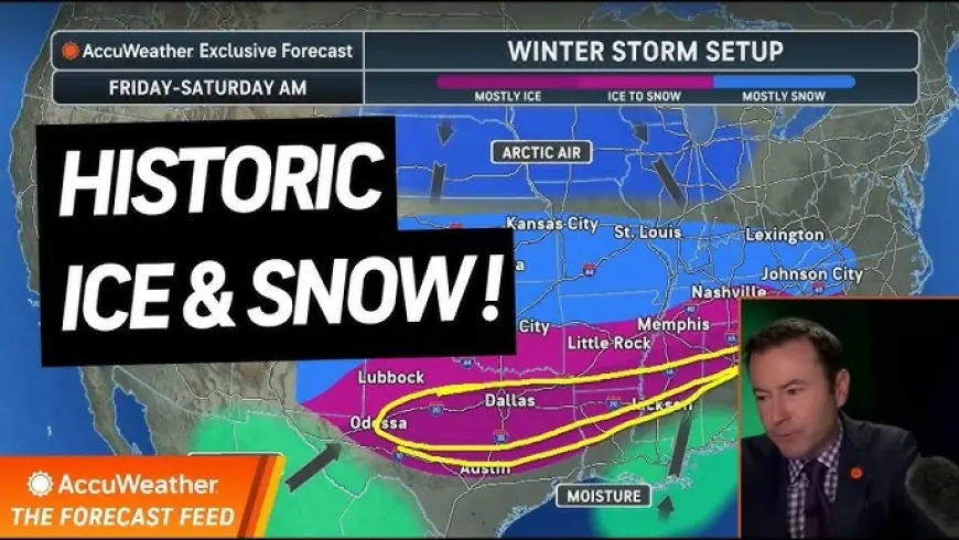
A major late-January winter storm is taking shape with the potential to spread heavy snow, sleet, and damaging ice from the Southern Plains into parts of the Southeast and up toward the Mid-Atlantic as the weekend approaches. The biggest concern isn’t just snow totals—it’s the combination of long-duration icing, difficult travel in areas that don’t handle ice often, and temperatures cold enough to keep roads and power lines hazardous for days.
The forecast track is still tightening up, but the overall setup is increasingly clear: Gulf moisture surges north while Arctic air spills south, creating a wide zone where precipitation can turn wintry and disruptive.
Snow storm weather forecast: What’s most likely between Jan. 23 and Jan. 26
-
A large winter storm is expected to ramp up on Friday, January 23, then push east through the weekend, with impacts lingering into Monday, January 26 in some areas.
-
Ice is the primary threat across a broad slice of the South—especially from parts of Texas through the Lower Mississippi Valley into Georgia and the Carolinas—where even a small shift in temperatures can flip rain into freezing rain.
-
A heavy-snow corridor is more likely on the colder (northern) side of the storm, potentially from parts of Oklahoma through the Ohio Valley, with a chance for significant totals into portions of the Mid-Atlantic depending on the track.
-
Travel disruptions are likely at both road and air hubs, and delays can cascade well beyond the storm’s peak because de-icing, road treatment, and tree cleanup take time—especially after an ice event.
-
A post-storm temperature crash increases the risk that refreezing keeps sidewalks and roads slick even after precipitation ends.
Where snow vs. ice is most likely (and why it can change fast)
This storm’s “line in the sand” will be the surface temperature near 32°F (0°C). When warm air rides over sub-freezing air near the ground, rain can freeze on contact—creating glaze ice that adds weight to trees and power lines.
A practical way to think about the map:
-
North of the transition zone: colder air is deeper → precipitation falls mainly as snow.
-
In the transition zone: temperatures hover near freezing → sleet/freezing rain mix is possible.
-
South of the transition zone: warmer air wins → mostly rain, but if cold air undercuts late, a quick change to ice can happen.
That’s why small shifts in storm track or the depth of cold air can move the worst icing risk by tens of miles—enough to change outcomes for a major metro area.
Timing snapshot: What to watch day by day
Wednesday, January 21 – Thursday, January 22:
Cold air remains entrenched in parts of the northern U.S., and localized snow can still affect commutes in the Great Lakes. Some areas are already dealing with accumulating snow and increasingly dangerous wind chills later in the week.
Friday, January 23:
Storm development accelerates over the Southern Plains. Snow and ice begin expanding, and the first widespread travel impacts typically show up as roads glaze over and visibility drops in heavier bands.
Saturday, January 24 – Sunday, January 25:
Peak-impact window for much of the South and parts of the East. The most disruptive icing often occurs overnight into morning hours when surface temperatures are lowest.
Monday, January 26:
Even as the main precipitation shield shifts away, lingering slick spots and power restoration can keep conditions hazardous—especially where temperatures stay below freezing.
Why this storm stands out: Infrastructure stress and “days-after” risk
Ice storms don’t just create slippery roads; they create load. A quarter-inch of ice can already cause problems. Around a half-inch or more, the odds rise for downed branches, snapped lines, blocked secondary roads, and extended outages—particularly where icing is widespread and persistent.
Another factor: many southern communities have fewer plows, less road-salt inventory, and fewer crews trained for prolonged icing. That doesn’t make the forecast “worse,” but it does raise the potential for longer recovery time if the storm hits hard.
This is why many forecasters are emphasizing preparation for a multi-day disruption, not a one-night snow event.
Historical context: The U.S. has seen how dangerous a South-focused winter outbreak can become when heavy precipitation overlaps with sustained subfreezing temperatures—especially when power and transportation networks are strained at the same time. The current setup is not guaranteed to match past extremes, but it carries similar vulnerabilities: long-duration cold, the possibility of widespread icing, and slower melt-off afterward.
Quick preparedness checklist if you’re in the impact zone
-
Charge phones/power banks and prep a flashlight (avoid relying on candles).
-
Set a plan for 48–72 hours of limited travel: water, shelf-stable food, any essential medications.
-
Protect plumbing: know how to shut off water; insulate exposed pipes if possible.
-
If you must drive: full tank, blanket, scraper, traction aid, and a way to get updates if cellular service is strained.
-
Track local advisories and school/office closures early—ice forecasts can force rapid changes.
FAQ
How far south can snow and ice reach with this storm?
Forecast guidance supports wintry impacts well into the South, including areas that rarely see significant ice. The exact southern edge depends on how quickly cold air arrives and holds.
When will we know the “bullseye” cities for snow vs. ice?
Confidence usually sharpens 24–36 hours before peak impacts, once temperature profiles and the storm track converge. Until then, expect adjustments.
What’s the biggest travel mistake people make in ice storms?
Assuming roads will improve quickly. With temperatures staying below freezing after the storm, refreezing can keep roads dangerous long after precipitation ends.
If you tell me your city or region, I can narrow this down into a tighter, location-specific snow storm weather forecast (timing, snow/ice type, and biggest risks).