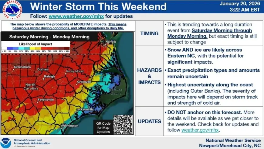
Winter Storm This Weekend: Snow and Ice Threat Expands From the South Into the Mid-Atlantic and Northeast (Jan. 23–25)

A sprawling winter storm is taking shape for this weekend, with a wide zone of potential impacts stretching from parts of the southern Plains and Deep South into the Appalachians, Mid-Atlantic, and portions of the Northeast. The biggest uncertainty is not whether wintry weather happens, but where the “changeover line” sets up—where cold air is deep enough for snow versus shallow enough to favor sleet or freezing rain.
For many communities, the highest-impact window looks to be late Friday into Saturday in the South, then Saturday into Sunday farther east and north. Travel conditions could deteriorate quickly as precipitation rates increase and temperatures fall, especially overnight.
Winter Storm This Weekend: The Setup Driving Snow, Sleet, and Ice
This system is being fueled by two classic ingredients arriving at the same time:
-
A push of Arctic air sliding south and east, dropping temperatures to (or below) freezing across a broad swath.
-
Gulf moisture surging northward, providing the precipitation that turns cold air into snow and ice.
When those overlap, small changes in storm track and temperature aloft can produce sharply different outcomes: heavy snow in one corridor, sleet in another, and a damaging glaze of ice farther south or closer to the coast.
Timeline: When the Worst Weather Is Most Likely
While timing will vary by state and even county, here’s the most useful weekend outline:
-
Friday (Jan. 23): Wintry precipitation begins in the southern Plains and lower Mississippi Valley, expanding eastward.
-
Friday night into Saturday (Jan. 24): Higher confidence for disruptive icing and/or accumulating snow across parts of the Southeast and southern Appalachians as colder air deepens.
-
Saturday into early Sunday (Jan. 25): The storm pushes into the Mid-Atlantic and possibly the I-95 corridor; parts of the Northeast may see a period of accumulating snow, with some areas flirting with rain or a mix near the coast.
-
Sunday (Jan. 25): Precipitation tapers in many areas, but lingering ice and refreeze risk can keep roads hazardous.
The most dangerous conditions often occur when precipitation is ending—when crews are stretched thin and temperatures drop fast, refreezing slush into black ice.
Regional Impacts to Watch Closely
Southeast: Ice Is the Main Worry
In parts of the Carolinas, Virginia border counties, and sections of the Deep South, the risk may lean toward freezing rain and sleet more than pure snow. Ice is typically the higher-impact hazard because:
-
It turns roads into skating rinks with minimal accumulation.
-
It can weigh down trees and power lines.
-
It’s difficult to treat once it sets in during active precipitation.
If your forecast mentions “mixed precipitation,” plan for slower travel than you would for a typical snow event.
Mid-Atlantic: High Bust Potential, High Reward for Snow Lovers
From the interior Piedmont through portions of Virginia, Maryland, Pennsylvania, and New Jersey, this looks like a classic battleground zone. In these areas, a shift of 25–50 miles in storm track can determine whether you see:
-
A plowable snow,
-
A sleet-heavy “cement” accumulation,
-
Or a brief snow that flips to rain near the coast.
Expect forecasts to tighten significantly as the storm gets closer and the cold air depth becomes clearer.
Northeast and NYC: A Snow Chance, But Coastal Mixing Is the Wild Card
For the New York City metro, the current signal points to a weekend snow potential rather than a guaranteed blockbuster. The coastal profile is sensitive: a slightly warmer track favors rain/mix; a colder, more offshore track favors heavier snow. Interior areas away from the immediate coastline generally have a better chance of staying all snow.
Western New York: Lake Effect Still Matters
If you’re in Western New York, don’t ignore the background lake-effect pattern. Even if the weekend storm’s core track misses you, lake-effect bands can produce localized whiteouts and sudden additional accumulations that complicate travel and school decisions.
How Many Inches of Snow This Weekend?
It’s too early for a single trustworthy “X inches” number across New York or the broader East because this storm’s precipitation type and track will vary by location. The better way to think about it right now:
-
Higher confidence: some corridor will see impactful accumulation (snow and/or ice).
-
Lower confidence: the exact line separating snow from sleet/freezing rain and rain.
-
Best planning approach: prepare for disruptive travel, then refine totals 24–36 hours out when the track is better locked.
Winter Storm Warnings, Watches, and What They Mean for You
If you see alerts issued for your area, treat them as action-oriented:
-
Watch: conditions are possible—start preparations, check travel plans, and expect updates.
-
Warning: conditions are expected or imminent—avoid unnecessary travel and secure essentials.
-
Advisory: impacts are likely but typically less severe—still enough to cause accidents and delays.
Practical Prep for the Weekend
-
Travel: top off gas, pack a charger/blanket, and avoid late-night driving if temperatures are near freezing.
-
Home: charge devices, set faucets to drip if a hard freeze arrives, and have a flashlight ready.
-
Work/school: anticipate late announcements; plan childcare and remote options if roads ice over.
If you tell me your city or ZIP (Buffalo, Syracuse, NYC, or elsewhere), I can narrow this to the most likely precipitation type (snow vs sleet vs freezing rain), the highest-risk hours, and a realistic range of totals for your specific area.


