


Weather Channel Issues Urgent Winter Storm Fern Alert as Snow and Ice Target the South and East
The Weather Channel is warning that Winter Storm Fern could become one of the most disruptive cold-season events of early 2026, with a messy mix of damaging ice, sleet, and heavy snow spreading from Texas toward the Southeast and the East Coast this weekend. The biggest concern isn’t just snow totals—it’s the ice potential in areas that rarely see prolonged subfreezing conditions, raising the risk of power outages, downed trees, and travel shutdowns.
The forecast focus has tightened in the past day as confidence grows that arctic air will collide with Gulf moisture, creating a wide swath of wintry precipitation. Exact lines will still shift, but the threat window is becoming clearer: Friday into the weekend, with impacts lingering into early next week where temperatures stay below freezing.
-
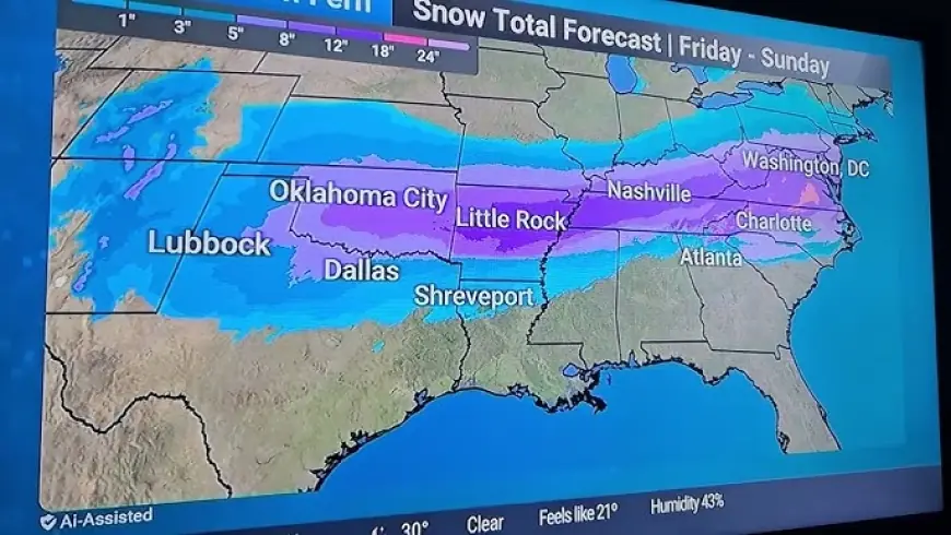
Winter Storm Fern is expected to spread wintry weather from Texas toward the Carolinas this weekend.
-
The highest-impact risk is ice accumulation in parts of the South where trees and power lines are vulnerable.
-
A corridor of heavier snow is possible farther north, with travel impacts expanding eastward.
-
Major hubs that often feel cascading delays include Dallas–Fort Worth, Atlanta, Memphis, Charlotte, and nearby interstates.
-
Forecast details remain track-dependent, so small shifts could change who sees mostly rain versus a dangerous glaze of ice.
What the Weather Channel says is different about this storm
Winter storms in the South tend to be disruptive even when totals look modest on paper, and this setup fits the classic high-risk pattern: shallow cold air at the surface plus warm, moist air aloft. That’s a recipe for freezing rain and sleet—precipitation types that can be more destructive than snow because they load ice onto trees, bridges, and power infrastructure.
The Weather Channel’s coverage is emphasizing three overlapping zones:
-
Ice zone (highest damage risk): where rain falls into subfreezing air and freezes on contact. Even a thin glaze can snap limbs and bring down lines.
-
Transition zone: where sleet and freezing rain swap back and forth, turning roads into a skating rink and making totals hard to pin down.
-
Snow zone: where cold air is deep enough for more persistent snow, increasing the chance of plowable accumulation and extended travel delays.
Who is most at risk, and when conditions deteriorate
The first impacts are expected in Texas, where temperatures drop quickly ahead of the system. From there, the wintry mix expands east and northeast across the weekend, potentially affecting parts of Louisiana, Mississippi, Alabama, Georgia, the Carolinas, and nearby regions depending on the storm track and the depth of cold air.
This is the kind of storm where timing matters as much as totals. If freezing rain begins overnight or during peak travel hours, disruption escalates fast. Another key factor: some areas could stay below freezing long enough that melting is slow, meaning icy roads and sidewalks can persist well after the heaviest precipitation ends.
Why power outages are a top concern in the South
The Weather Channel’s alert tone reflects a practical reality: much of the South is not built for extended icing. Trees can retain leaves longer into winter in some areas, and that extra surface area helps ice build faster. Add gusty winds and you get the classic outage scenario—branches fail, lines come down, and crews struggle to access neighborhoods because roads are impassable.
If you live in the ice-risk zone, preparation isn’t dramatic—it’s basic resilience:
-
Charge devices and battery packs
-
Fuel vehicles and keep a blanket, water, and snacks in the car
-
Locate flashlights (not candles) and check batteries
-
Protect pipes and bring pets inside
-
Plan for a “no driving” window if freezing rain begins
How to use the Weather Channel tools without getting overwhelmed
For many people, “Weather Channel” means the TV feed. But the most actionable advantage is often the combination of radar, alerts, and hour-by-hour timing. During a mixed-precipitation event, the “what time does it change over?” question is everything.
A smart way to monitor:
-
Watch for ice accretion wording (not just “wintery mix”)
-
Track temperature forecasts by hour, not daily highs/lows
-
Treat any mention of “below freezing into Monday” as a signal that impacts could linger
-
Check whether your area is near the rain/ice line, because that boundary is where forecasts shift most
This is also where caution helps: if you’re right on the edge, a 30–50 mile shift can change your outcome completely.
A decade ago, many Southern winter disruptions were framed as “unexpected.” Now, the pattern is familiar: arctic air pushes farther south, Gulf moisture rides over it, and a narrow band of ice becomes the main story. The infrastructure challenge hasn’t changed much, which is why these storms still punch above their weight in economic and travel impact.
FAQ
Is Winter Storm Fern definitely bringing snow to my city?
Not guaranteed. The biggest uncertainty is the storm track and the rain/ice line. Many places will see a mix that changes over by the hour.
Why is ice more dangerous than snow?
Ice adds weight to trees and power lines and creates near-invisible road hazards. Even small amounts can cause widespread outages and crashes.
When should I stop traveling?
If freezing rain or sleet is forecast during your travel window, the safest move is to change plans early—roads can become hazardous faster than crews can treat them.
Over the next 48–72 hours, the key signal to watch is whether the colder air holds firm as moisture arrives. If it does, the risk shifts from “sloppy winter weather” to a longer-lasting disruption event—especially in the Southeast. If the cold retreats even slightly, some locations flip to rain and impacts drop sharply. Either way, the Weather Channel’s central message stands: this storm is less about novelty and more about timing, ice, and infrastructure stress—the combination that turns a forecast into a real-world shutdown.


