


Extreme Cold Front Engulfs Middle Tennessee: First Alert Forecast
The cold weather gripping Middle Tennessee is set to persist a few more days, with minor relief expected by the week’s end. A cold front has brought temperatures down significantly, prompting a first alert forecast for residents.
Current Weather Conditions
As of now, early morning temperatures are hovering in the teens and 20s. Although plenty of sunshine is forecasted, high temperatures will only reach the mid-30s this afternoon. Due to the wind chill, it will feel even colder, with effective temperatures in the 20s.
Tonight’s Forecast
- Overnight Temperatures: Falling back into the teens and 20s.
- Sky Conditions: Clear throughout the night.
Detailed Forecast for the Week
Monday’s Weather
- Morning: Starting temperatures in the teens and 20s.
- Afternoon: Sunny, with highs in the low to mid-30s.
- Evening: Clear skies, lows again in the teens and 20s.
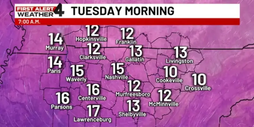
Tuesday’s Outlook
- Morning: Expected to be the coldest morning yet, with temperatures in the teens and some areas possibly dropping to single digits.
- Afternoon: Mostly sunny, reaching highs in the 30s.
- Evening: Temperatures will drop back to the teens and 20s.
Mid-Week Warm-Up
By Wednesday, a gradual warm-up will begin, bringing temperatures back into the upper 40s. Late Wednesday night, rain is likely, transitioning to a wintry mix as temperatures approach freezing. However, any wintry precipitation is expected to be brief and will not accumulate significantly.
End of the Week Weather
On Thursday, conditions are expected to clear, with temperatures in the 40s and plenty of sunshine. Friday afternoon could see temperatures reaching into the 50s, but a new cold front is predicted to arrive late Friday, bringing colder weather into the weekend.
Residents should prepare for fluctuating temperatures and potentially hazardous conditions as this extreme cold front continues to affect Middle Tennessee.