


How Much Snow Are We Getting? Fresh Projections by Region, Timing, and Impacts
A new burst of winter weather is sweeping the Northeast and parts of the Mid-Atlantic, with two waves bringing accumulating snow through the weekend. Recent updates indicate the Sunday system is tracking a bit closer to the coast than earlier runs suggested, boosting totals for some communities. Forecasts remain subject to adjustment as bands set up, but confidence is high for plowable snow in portions of southern New England and the New York tri-state, with lighter amounts west and south.
How much snow are we getting today and Sunday?
-
Southern New England (eastern MA, RI, southern NH): Widespread 3–6 inches, with localized 7–9 inches where steadier banding persists. Coastal mixing looks limited; the colder track favors mainly snow.
-
Connecticut: Generally 3–6 inches by late Sunday, with higher pockets possible near the I-84 corridor and interior hills if a deformation band stalls.
-
New York City metro / northern NJ / Lower Hudson Valley / western Long Island: Two rounds—light to moderate bursts early, with the Sunday daytime wave bringing the bulk: 3–7 inches, highest north and west of the city; 2–5 inches closer to the coast.
-
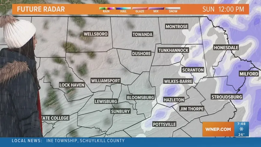
Central and eastern Pennsylvania (including the Susquehanna Valley): Coating to 1 inch, a bit more in elevated or far-northeastern spots if snow bands clip the region.
-
Interior New England (central/northern MA into southern ME and interior NH/VT): 2–5 inches in most towns, with locally higher totals under persistent bands.
These ranges reflect the latest consensus; sharp gradients are likely near the rain/snow line and along the immediate shoreline.
Timing: When the snow arrives and ends
-
Saturday night to early Sunday (ET): Flurries and light snow expand north; slick spots develop on untreated roads before daybreak.
-
Sunday morning: A coastal low strengthens and nudges closer to the shoreline. Steadier snow overspreads CT, RI, eastern MA, and the NYC metro. Visibilities drop under heavier bands.
-
Sunday afternoon: Peak impacts for the I-95 corridor from NYC to Boston. Snow may fall moderate at times, especially just inland. Temperatures remain cold enough for accumulation.
-
Sunday evening: Snow tapers west to east. Lingering light snow or flurries exit the coastline late evening to early night.
-
Early week: Colder, breezy air settles in, allowing any untreated slush to refreeze overnight.
Note: Exact start/stop times vary neighborhood-to-neighborhood; a 1–2 hour shift is common with coastal systems.
Why totals just increased in some areas
Short-range guidance trends place the low a touch closer to the coast during peak development. That seemingly small wobble brings:
-
Stronger lift: Enhances snow growth and banding, boosting rates.
-
Slightly colder profiles: Reduces mixing risk near the shoreline.
-
Focused deformation zone: A narrow ribbon of heavier snow that can deliver 1”+ per hour for bursts, creating local “jackpots.”
Because banding is narrow, a town 10–15 miles away could see noticeably different totals. Treat the ranges above as a likely window, not a guarantee to the tenth.
Travel, power, and school impacts
-
Roads: Expect slick to snow-covered conditions during Sunday’s daytime commute hours in the hardest-hit zones. Crews will have trouble keeping up during peak bursts.
-
Air travel: Periods of reduced visibility and deicing delays are possible at major hubs from NYC through Boston during the afternoon push.
-
Power: Winds look moderate, not extreme; the snow is trending dendritic and relatively dry, which lowers but doesn’t eliminate tree-load concerns, especially where totals top 6 inches.
-
Schools/activities: Sunday events may see cancellations; Monday morning could feature icy side streets if overnight refreeze occurs.
What could still change
Winter storms near the ocean are notoriously sensitive to track and temperature:
-
Coastal mixing risk: A subtle warm layer aloft could trim totals right at the beaches; a colder column would keep it all snow.
-
Band placement: If the heaviest band sets up 25–40 miles farther inland or out to sea, winners and losers swap quickly.
-
Clipper enhancement: A secondary wave behind the main low could add a bonus 0.5–2 inches in spots if it phases correctly.
Recent updates indicate a more favorable setup for snow along and just inland of I-95 from NYC to Boston, but details may evolve.
Quick look: projected ranges
| Region | Likely Range | Local Peaks | Main Window (ET) |
|---|---|---|---|
| Southern New England (RI/eastern MA/southern NH) | 3–6" | 7–9" | Sun 7 a.m.–8 p.m. |
| Connecticut | 3–6" | 6–8"+ hills | Sun 8 a.m.–7 p.m. |
| NYC metro & northern NJ | 3–7" | 5–7"+ N/W suburbs | Sun 9 a.m.–7 p.m. |
| Long Island (west/central) | 2–5" | 4–6" interior | Sun 10 a.m.–7 p.m. |
| Central/Eastern PA (Susquehanna Valley) | Coating–1" | 1–2" localized | Sat night–Sun noon |
| Interior New England | 2–5" | 5–7" under bands | Sun morning–evening |
If you’re in southern New England, Connecticut, or the NYC metro, plan for plowable snow Sunday with the highest odds of 3–7 inches, and room for locally higher totals where bands park. Farther west and south, lighter accumulations will still create slippery travel at times. Check the latest neighborhood-level forecast and road advisories before heading out; details will be refined as the storm evolves.


