


NYC Weather Today: Snowy Sunday Turns Slushy, Then a Quick Freeze Grips the City
A wintry Sunday greets New York City with on-and-off snow and some mixed rain early, keeping many streets mainly wet through midday before conditions deteriorate toward evening. The brief slush won’t last long: a sharper freeze arrives overnight, setting up a colder, brighter start to the new week.
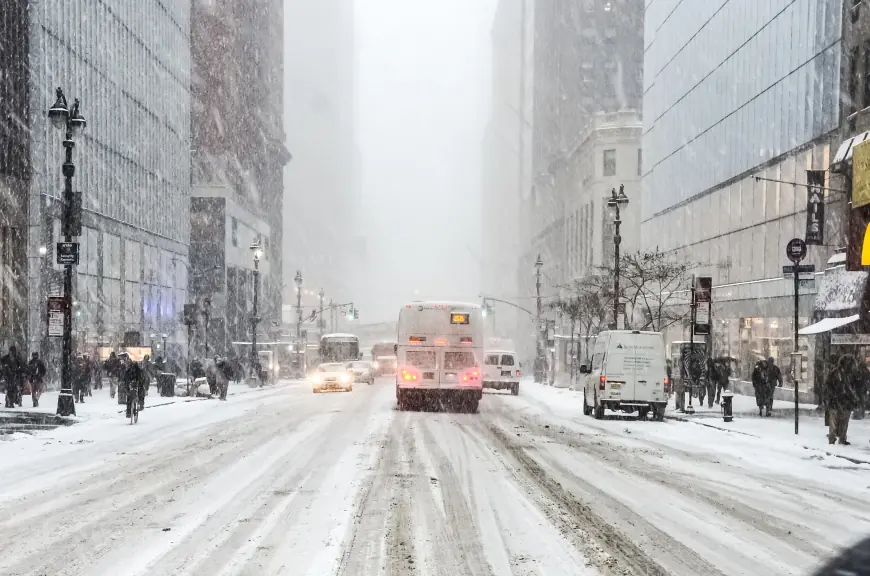
NYC weather today (Sunday, Jan 18)
Light snow pulses through the day, with rain at times near the coast and lower Manhattan. Surfaces stay mostly wet for a while in the urban core, but untreated sidewalks and bridges can grow slick late afternoon into evening as temperatures slip back toward the 20s. Plan for slower commutes late day and a more wintry feel after sunset.
-
High: near 37°F (3°C)
-
Evening low: near 26°F (-3°C)
-
Travel note: wet-to-slick transition after dark, especially on elevated or less-traveled roads.
Monday: Colder, a bit breezy, and partly sunny
The storm clears. Skies break for sun, but it will feel noticeably colder. A light afternoon breeze adds edge to the chill.
-
High: around 33°F (1°C)
-
Low: near 20°F (-6°C)
Tuesday: Coldest day of the stretch
Plenty of sun, little moderation. Dress for mid-winter.
-
High: near 25°F (-4°C)
-
Morning low: near 16°F (-9°C)
Midweek moderation with more clouds
A gradual thaw tries to nudge in by Wednesday, though it comes with increasing cloud cover. Thursday trends mostly cloudy and seasonably chilly before another cool, partly sunny finish Friday into Saturday.
-
Wednesday: High near 37°F (3°C), Low near 33°F (1°C)
-
Thursday: High near 39°F (4°C), Low near 23°F (-5°C)
-
Friday: High near 32°F (0°C), Low near 29°F (-2°C)
-
Saturday: High near 32°F (0°C), Low near 17°F (-8°C)
What this means for NYC travel and plans
-
This evening: Watch for pockets of black ice as temperatures dip. Side streets, on-ramps, and bridges cool first.
-
Monday morning: Icy spots may persist in shaded areas; allow a little extra time for commutes.
-
Outdoor activities: Tuesday is the brisk outlier—limit exposure and layer up; wind can enhance the chill even under sun.
-
Midweek errands: Wednesday into Thursday offers the most comfortable window, though skies look grayer.
Temperature trend at a glance
| Day | AM Low | PM High | Sky/Notes |
|---|---|---|---|
| Sun (Jan 18) | 26°F | 37°F | Snow at times; slushy, turning slick late |
| Mon (Jan 19) | 20°F | 33°F | Partly sunny; a bit breezy |
| Tue (Jan 20) | 16°F | 25°F | Mostly sunny, cold |
| Wed (Jan 21) | 33°F | 37°F | Clouds increase |
| Thu (Jan 22) | 23°F | 39°F | Cloudy |
| Fri (Jan 23) | 29°F | 32°F | Partial sunshine |
| Sat (Jan 24) | 17°F | 32°F | Sunny, crisp |
Forecast timing and amounts can shift; check for any rapid updates if you have time-sensitive plans.
Quick tips for the next 48 hours
-
Footing: Late today into early Monday, assume slick patches in shade and on metal grates or stairs.
-
Car care: Brush off slush before the evening freeze to prevent ice build-up.
-
Layers: Monday and Tuesday warrant winter gear—hat, gloves, and insulated layers.
-
Pets & pipes: Shorten pet walks during the coldest periods; consider a slow drip for vulnerable pipes Tuesday morning.
NYC’s brief Sunday slop gives way to a crisp, colder early week, followed by a modest midweek rebound under thicker clouds. Plan around tonight’s freeze and the sharp chill Tuesday, and you’ll be well positioned for the quieter finish to the workweek.


