


Nor’easter Set to Blanket Nova Scotia in Snow by Monday
Nova Scotia is preparing for a significant winter storm as a nor’easter is set to blanket the region in snow starting Sunday night. The storm will persist into Monday, impacting travel and causing hazardous conditions.
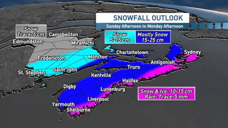
Storm Details and Timing
The nor’easter is expected to bring heavy snow, with the most intense conditions beginning late Sunday afternoon. Snow accumulation will continue overnight, leading into Monday morning.
Expected Snowfall Amounts
- Most of Nova Scotia: 15 to 25 cm
- Prince Edward Island: 15 to 25 cm
- Northern Nova Scotia (higher terrain): up to 30 cm
- Southern New Brunswick: lower totals
- Atlantic coastline and southern Cape Breton: 10 to 15 cm
Weather Conditions
The snowfall will consist of wet and dense powder, increasing the difficulty of shoveling and the risk of power outages. Weather warnings are in effect as the storm tracks towards the region.
Mixed Precipitation
Along the Atlantic coastline, residents should expect a mix of snow, ice pellets, freezing rain, and rain. This mix will likely lead to lower overall snowfall totals but will complicate cleanup efforts.
Travel Impact
Travel delays and cancellations are anticipated for Monday morning. Conditions will worsen as the storm develops overnight.
Wind Conditions
Gusty northeast winds will reach speeds of 20 to 50 km/h. As the system shifts, expect winds to change to northwest at similar speeds.
Forecast Updates
Forecast uncertainties remain regarding the track of the nor’easter. Updates on snowfall totals and storm progression will be provided as the storm approaches.
Residents are encouraged to prepare for difficult conditions and stay informed of local weather updates through trusted sources like Filmogaz.com.


