


N.J. Braces for 4 Inches of Snow in Consecutive Winter Storms
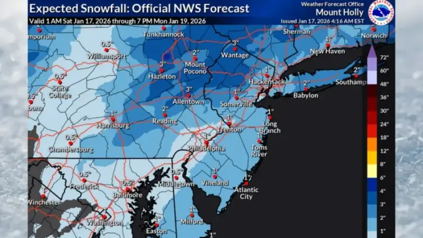
New Jersey is preparing for a significant winter weather event this weekend, with two back-to-back storms. Snow accumulations are expected to range from 2 to 4 inches on Saturday, particularly in the northern regions. The forecast indicates an additional 1 to 2 inches of snowfall on Sunday, primarily affecting the southern half of the state.
N.J. Snow Accumulation Expectations
The National Weather Service has issued a winter weather advisory for several counties, including:
- Morris
- Sussex
- Warren
- Western Passaic
This advisory is in effect until 4 p.m. on Saturday. The most substantial snowfall from Saturday’s storm is predicted to occur north of Interstate 78, where snowfall rates could exceed 1 inch per hour between 9 a.m. and 1 p.m.
Forecast for Southern Areas
Counties located between Interstate 78 and Interstate 95 are expected to see minimal accumulation, generally around 1 inch or less. In regions south of I-95, temperatures are forecasted to rise, transitioning snowfall to rain by mid-morning, resulting in little to no snow accumulation.
Sunday’s Weather Outlook
Sunday will bring another round of light snow, particularly affecting areas along and south of Interstate 95. As a coastal storm brushes the Jersey Shore, light snow is expected to begin early Sunday morning and continue through the early evening.
Snow totals for Sunday may reach up to 2 inches in certain locations, with notable accumulations likely in:
- Atlantic County
- Cape May County
- Southwestern Burlington County
- Southern Ocean County
There is a 30% chance that these areas will receive over 2 inches of snow. However, uncertainty remains regarding storm accumulations in coastal areas due to potential rain mixing with the snow.
Cold Weather Following Storm
Following the storms, a period of below-normal temperatures is anticipated from Sunday night through Wednesday. The coldest temperatures are expected Monday night into Tuesday, with wind chills dropping into the single digits.
Tuesday is expected to be particularly harsh, with high temperatures remaining in the 20s across the state. Conditions may moderate mid-week, potentially bringing temperatures back to normal or above normal levels by Thursday.
Future Storm Possibilities
According to AccuWeather’s long-range forecast, changes in the jet stream next week could lead to additional snow and ice events in New Jersey. Meteorologists indicate that a more west-to-east jet stream pattern may ease the extreme cold temporarily while introducing new winter storms.
Residents are encouraged to stay informed and prepare for a snowy weekend ahead as multiple winter storms impact New Jersey this weekend.


