


Snow Bursts and Gusty Winds May Rapidly Reduce Visibility Tonight
Severe winter weather is anticipated across parts of Kansas and Missouri, prompting officials to issue a Snow Squall Warning. Affected areas include Johnson County and Miami County in Kansas, as well as Cass County and Jackson County in Missouri. This warning will remain in effect until 5:45 PM.
Impacts of Incoming Snow and Winds
Travelers should prepare for quick bursts of snow, which could bring heavy snow showers and wind gusts up to 40 mph. These conditions may rapidly reduce visibility for commuters heading home or to evening events. Accumulations are expected to be light, ranging from a dusting to half an inch.
Evening Travel Advisory
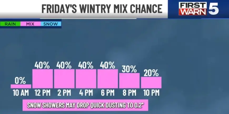
- Chance of wintry mix: 40% in the afternoon, increasing to 60% during evening commute.
- Recommended to delay non-essential travel until conditions improve.
- If snow or poor visibility occurs, slow down and seek safe areas to pull over.
As snow begins to settle, isolated slick spots may form, especially where the heaviest bands of snow develop. Following this weather event, expect temperatures to drop significantly, with evening lows forecasted to fall into the 20s.
Weekend Cold Snap and Future Forecasts
Saturday will see a continuation of the frigid weather, as sub-freezing temperatures bring hazardous wind chills. Morning temperatures in the Kansas City metro area are projected to hover around 14 degrees, with wind chills near zero.
Saturday Predictions
- Saturday high temperatures may only reach around 20 degrees.
- Wind chills expected to remain in single digits throughout the day.
- Dress in multiple, loose layers and ensure protection with hats, mittens, and warm footwear.
On Sunday, the cold spell will peak, with morning lows expected to dip into single digits. Wind chills could range from -5 to 0 degrees. Fortunately, sunshine will help raise afternoon temperatures into the low 40s.
Looking Ahead to Monday and Beyond
Monday is predicted to maintain winter-like conditions, starting the day in the teens and reaching mid-20s by afternoon. Wind speeds will be milder, reducing the severity of wind chills. It’s advisable to continue wearing winter gear.
The work week will see a shift, with temperatures moderating into the 40s starting Tuesday. Sunny skies are forecasted to bring much-needed relief after the chilly weekend storms.


