


Snow Arrives as Bitter Cold Follows This Thursday
Residents of Knoxville, Tennessee, are bracing for significant weather changes as a cold front moves into the area. The arrival of this front will bring light rain, snow, and a drastic drop in temperatures.
Impact of the Cold Front
On Wednesday, temperatures will primarily remain in the 40s but will not rise significantly throughout the day. Cloud cover is persistent and will lead to cold rain starting in the afternoon. Winds from the west and northwest are expected to increase by evening.
Transition to Snow
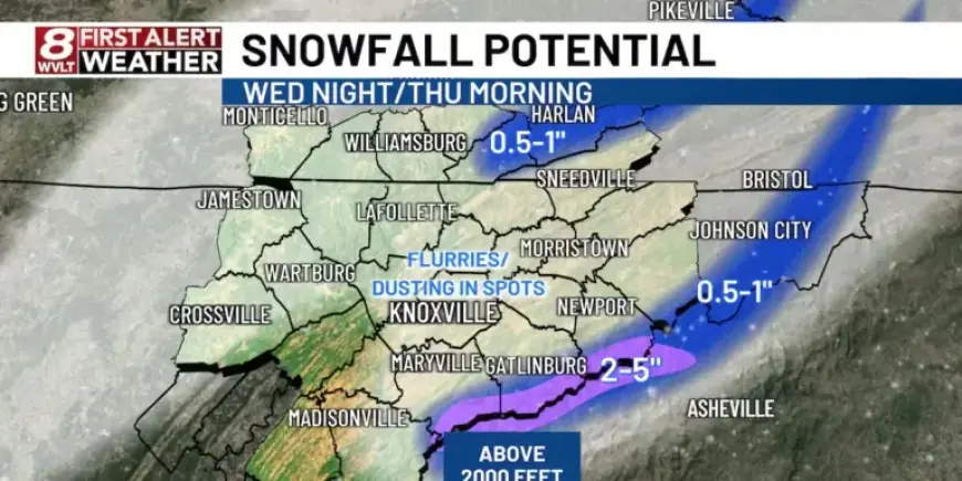
Between 4 PM and 8 PM, rain is forecasted to turn into wet snowflakes, particularly in mountainous regions. As the evening progresses, areas under Winter Weather Advisories and Winter Storm Warnings will experience significant snowfall.
- 2-5 inches of snow are anticipated in the highest elevations.
- Higher peaks may accumulate up to 8 inches.
- Foothills and parts of the Cumberland Plateau might see a dusting to an inch.
- Some flurries are possible in Knoxville, but accumulations will be minimal.
Bitter Cold Conditions
As temperatures plunge on Thursday, highs will only reach the 30s. The wind chill will make it feel like the teens or single digits throughout the day. Overnight temperatures are forecasted to drop into the teens and 20s, necessitating extra layers for outdoor activities.
Weekend Weather Outlook
The cold spell will continue into the weekend, with high temperatures projected in the 30s near 40 degrees. Overnight lows are expected to hover around the 20s. A slight chance of passing showers or snow flurries remains, especially on Saturday night.
Residents are advised to stay updated on weather alerts and prepare for these frigid conditions.


