


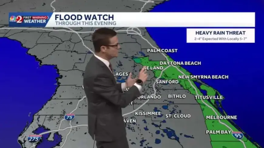
Flood Threat Looms Over Central Florida Amid Heavy Rains
Heavy rains have settled over Central Florida, raising a clear flood threat for parts of the region. Meteorologists warn that widespread downpours and gusty winds will disrupt travel and daily routines.
Forecast and timing
Impact weather is expected through Tuesday and Wednesday. Rain chances remain elevated into Thursday, then taper later in the week.
- Today: roughly 80% coverage of rain across the region.
- Morning commute: widespread rain with slick roads and reduced visibility.
- Late morning into afternoon: rain shifts eastward with pockets of heavy downpours.
- Seven-day outlook: select areas along the I-95 corridor could see 3 to 5 inches.
- Metro zones: generally forecasted to receive about 0.5 to 2 inches.
- Wind gusts: commonly 20 to 30 mph, with isolated gusts near 35 mph.
- Temperatures: remain in the lower 70s for the next couple days.
Where the risk is highest
The greatest flood concern is concentrated along the I-95 corridor. Poorly drained neighborhoods and coastal communities face elevated threat levels.
- Ocala area noted as relatively drier compared with coastlines.
- Volusia County: Daytona Beach, Central Volusia, and Palm Coast.
- Flagler Beach and parts of Brevard County, including Port Saint John.
- Southern Brevard into Indian River County: Floridana Beach, Grant-Valkaria, Micco.
- Interior corridors: Lake Weir, Leesburg, Howey-in-the-Hills, and Orlando metro.
Watches, warnings and official updates
Flood watches and wind advisories are currently posted. Local weather centers urge close monitoring of conditions.
The Weather Prediction Center recently upgraded its assessment along the I-95 corridor. Areas that were being monitored moved to a higher probability of flooding.
Impact and safety guidance
Travel will be affected during the peak morning drive. Expect delays from standing water and gusty winds.
- Do not drive through flooded roadways. Turn around, don’t drown.
- Reduce speed and increase following distance on wet roads.
- Secure loose outdoor items that could blow away in gusts.
- Prepare for possible localized power outages in stronger wind pockets.
Context and local coverage
This system may help alleviate parts of the seasonal drought. Meteorologists caution that too much rain too fast can create serious problems.
For continuous updates, filmogaz.com will carry live radar and alerts. The First Warning Weather team providing coverage includes Tony Mainolfi, Eric Burris, Marquise Meda, Cam Tran and Victoria Wisniewski.