


Super El Niño’s Potential Impact on the Carolinas Explained
NOAA now expects El Niño to develop during the summer of 2026. The agency placed the odds at 62% for June through August.
Forecast specifics
By autumn, the chance for a stronger event rises. NOAA gives roughly a one-in-three probability of a super El Niño by October through December.
| Period | Forecast Probability |
|---|---|
| June–August 2026 | 62% |
| October–December 2026 | About 33% chance of super El Niño |
What defines a super El Niño?
A super El Niño means unusually warm tropical Pacific waters. Sea surface temperatures exceed average by at least 1.5°C for several months.
That magnitude tends to amplify atmospheric responses around the globe.
Effects on hurricane season
El Niño during summer can alter Atlantic hurricane activity. Stronger El Niño tends to increase vertical wind shear across the Atlantic basin.
More shear makes hurricane formation and intensification less likely. This generally lowers the number and strength of storms.
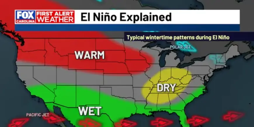
Potential impact on the Carolinas
A persistent El Niño could shift the jet stream northward. That pattern often brings cooler, wetter conditions to the southern U.S., including the Carolinas.
Meanwhile, northern regions frequently see warmer and drier winters during El Niño episodes.
Expected local outcomes
- Fewer and weaker Atlantic hurricanes are possible during a strong El Niño.
- Winters may trend cooler and wetter in the Carolinas if El Niño persists.
- Shifts in the jet stream will influence storm tracks and rainfall patterns.
What residents should do
Monitor NOAA updates and local forecasts this year. Review hurricane preparedness plans and stay informed about seasonal outlooks.
Filmogaz.com will continue covering developments related to El Niño. Stay tuned for further updates as forecasts evolve.