


Tropical Cyclone Horacio: tropical cyclone horacio becomes Earth’s first Category 5 of 2026
Tropical cyclone horacio reached Category 5 strength in late February 2026, becoming the world’s first Category 5 tropical cyclone of 2026. The system peaked with sustained winds of 160 mph (260 km/h) over the remote South Indian Ocean and is now moving southward and weakening.
Tropical Cyclone Horacio intensity
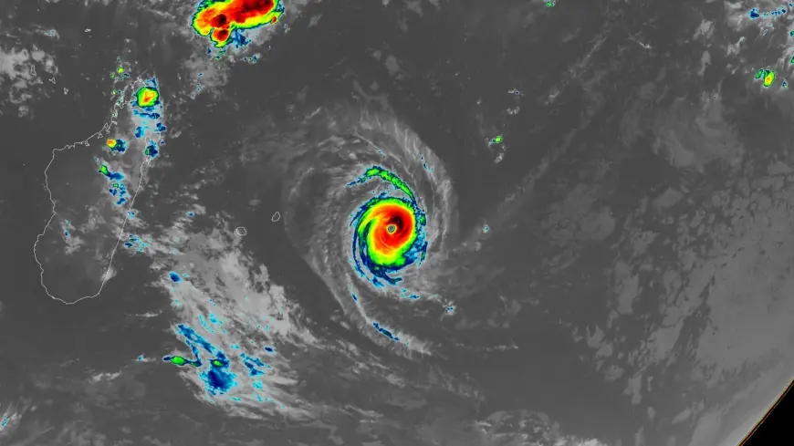
Tropical Cyclone Horacio intensified to a Category 5-equivalent system over the central Southwest Indian Ocean east of Mauritius on February 22, 2026 and was identified as the world’s first Category 5 tropical cyclone of 2026 on Monday afternoon, February 23. The Joint Typhoon Warning Center assessed 1-minute sustained winds of about 260 km/h (160 mph). At its peak between February 22 and 23, RSMC La Réunion estimated 10-minute sustained winds around 230 to 240 km/h (140 to 150 mph), gusts near 280 to 300 km/h (175 to 185 mph), and a central pressure of approximately 910 hPa. Satellite imagery showed a symmetrical eye structure and strong convective bands; a satellite image was captured at 04: 00 UTC on February 24, 2026.
Development and rapid intensification
The system developed from a low-pressure disturbance east of Rodrigues Island on February 18 and was named by RSMC La Réunion on February 19. Within 48 hours it underwent rapid intensification over warm waters with favorable upper-level outflow, reaching a very intense status by February 22. Sea surface temperatures were measured at 27-28 degrees Celsius (81-82°F) and wind shear was described as moderate during intensification.
Warnings for Rodrigues Island
Outer rainbands brought periods of rain and strong gusts to Rodrigues Island, where winds reached around 100 km/h (60 mph) and seas exceeded 6 to 8 m (20 to 26 feet). The Mauritius Meteorological Services maintained a Class 1 Cyclone Warning until February 23 and then lifted it as the system moved away. MMS issued a Heavy Swell Warning for Rodrigues at 04: 30 LT (00: 30 UTC) on February 24, valid until 04: 00 LT (00: 00 UTC) on February 25. A bulletin warned: "High-energy swells generated by the Intense Tropical Cyclone Horacio are influencing the sea state around Rodrigues. The sea will be high with swells of 7 m (23 feet) beyond the reefs. The waves will also influence the lagoons and may break along the low-lying coastal areas, especially during high tides. " Fishermen, pleasure-craft operators, and the public were strongly advised not to venture at sea or along beaches while the warning remained in effect. No major damage or casualties were reported.
Forecast and weakening trajectory
The Joint Typhoon Warning Center is predicting that Horacio has peaked in intensity and will steadily weaken as it moves southward over cooler waters into a region with higher wind shear. At 06: 00 UTC on February 24, Horacio’s center was about 315 km (196 miles) southeast of Rodrigues, continuing south while weakening. Forecasters at RSMC La Réunion noted at 07: 32 UTC on February 24: "Regarding the intensity forecast, environmental conditions will gradually deteriorate, with increasing vertical wind shear partially offset by strong upper-level divergence and an outflow channel to the southeast. " The system is forecast to continue weakening and to transition into a post-tropical system within 48 hours while moving southward over open waters. Horacio remains far from any land areas and is described as a threat primarily to marine interests.
Historical context and climate signals
Horacio is the first Category 5 in the Southern Hemisphere since Cyclone Errol achieved that status off the coast of northwestern Australia on April 16, 2025. The 1990-2025 average yearly number of Category 5 storms globally was 5. 3. There were five Category 5 storms in 2025: Hurricanes Melissa, Erin, and Humberto in the Atlantic; Typhoon Ragasa in the Northwest Pacific; and Cyclone Errol in the South Indian. Climate change is expected to increase the proportion of tropical cyclones that reach Category 4 and 5 strength.
Author and scientist Jeff Masters, Ph. D., published a report on the event on February 23, 2026. Masters worked as a hurricane scientist with the NOAA Hurricane Hunters from 1986 to 1990 and left that unit after a near-fatal flight into Category 5 Hurricane Hugo. The written work is released under a Creative Commons Attribution-NonCommercial-NoDerivatives 4. 0 International License and may be republished for free online or in print under those terms.
Satellite observations and agency assessments continue to track the storm as it weakens over the open Indian Ocean.