


Freeze Watch Issued for Central Florida as Arctic Blast Approaches
A freeze watch has been issued for parts of Central Florida as dangerously cold wind chills arrive. The region will shift from mid- to upper-70s on Sunday to a sharp blast of Arctic air that brings sub-freezing pockets, advisories and closures through early next week.
Cold front, showers and drought
A cold front moves through Central Florida Sunday, bringing scattered showers and even a few downpours. Temperatures Sunday reached the mid to upper 70s before cooler air settles in later in the afternoon. With drought conditions continuing to worsen, the rain will not make much of a difference. Showers will start to taper off by around 1-2 PM as the front pushes through by mid-afternoon; after lunch clouds are expected to clear from north to south and breezy, chillier conditions will take over.
Wind, fire risk and advisories
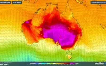
Gusty conditions combined with very low humidity have triggered a Red Flag Warning and a Fire Weather Watch in parts of the area. It is not a good time for any outdoor burning. Wind will be blustery on Monday, making for brutal wind chills; highs are expected to be around 20° below normal for this time of year on Monday. Afternoon readings later in the day are expected to be around 15° below normal.
Freeze Watch details and timing
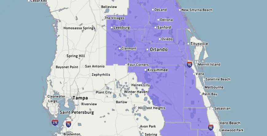
A Cold Weather Advisory is in effect from 3 a. m. to 9 a. m. Monday for dangerously cold feels-like temperatures, and a Freeze Watch goes into effect Monday night into Tuesday. Central Floridians will wake up to yet another cold watch on Tuesday, February 24. A separate freeze warning has been issued for a large swath of Central Florida for Tuesday from 3 a. m. to 9 a. m.
Temperatures by day and night
Sunday night temperatures will plummet back into the middle to upper 30s with wind chills around freezing and below to start off Monday. Monday morning will see temperatures in the 30s and 40s with wind chills dropping into the 20s and 30s; Monday afternoon will be bright and chilly with highs only in the lower to middle 50s and breezy conditions persisting. Monday night into early Tuesday is expected to be the coldest morning of the week with lows in the lower to middle 30s around the metro. Tuesday morning looks even colder: some spots could wake up in the 20s with wind chills in the mid to upper 20s, and some spots northwest of Orlando could be in the upper 20s or slide below freezing. During Tuesday’s freeze watch, sub-freezing temperatures as low as 30 degrees are possible.
County, city warnings and advice
Freeze Watches and warnings affect multiple counties and locales. Freeze Watches have been issued for Marion, Sumter, and Flagler counties, as well as the localities in Alachua, Levy, and Gilchrist counties. The freeze warning for Tuesday from 3 a. m. to 9 a. m. includes the cities of Celebration, Orlando, Kissimmee, Oviedo, and Clermont. Residents are advised to cover plants and bring pets inside.
Closures, impacts and related notes
Due to the cold, Disney’s Blizzard Beach water park is closed on both Monday and Tuesday this coming week. Area water parks have closed a few times so far in 2026 because of the cold. The area suffered a hard freeze at the end of January. Other local notes from recent coverage: Showtime-era Lakers royalty including Magic Johnson, Kareem Abdul-Jabbar and James Worthy showed up Sunday for Riley’s statue ceremony; Jacob Bridgeman said he "couldn't even feel my hands" on the final few holes on Sunday afternoon at Riviera Country Club. Additional national items noted alongside the forecast included that NASA is rolling the SLS rocket off the launch pad to investigate a helium flow issue encountered over the weekend, and that the 2026 Milan Cortina Olympics are officially over.
The weather information was provided by meteorologist T. J. Springer on February 22, 2026. Michelle joined as a meteorologist in May 2023. If you need help with the Public File, call 291-6000.
Warmer air is expected to return later: the warming trend begins mid to late week with highs back in the 80s by Thursday, and temperatures should start to rebound by the middle of the week.
Stay prepared: note the Cold Weather Advisory hours, the Monday night into Tuesday Freeze Watch and freeze warning windows, protect sensitive plants and animals, and expect gusty winds and very low humidity through the early part of the week.