


Freeze Watch Raises Immediate Concerns for Central West Florida Residents as Temperatures Drop Toward the 20s
Why this matters now: A freeze watch is in effect for Central West Florida and inland pockets are likely to feel the impact first — with temperatures expected to dip to 27 and overnight lows falling near freezing in some areas. The combination of a cold front, gusty winds and early‑morning advisory windows means residents, growers and anyone with outdoor responsibilities will need to adjust plans for Monday and Tuesday.
Freeze Watch: who feels it and how — immediate impacts
Here’s the part that matters: the freeze watch signals risk for Central West Florida locations that already face a quick swing from mild conditions to near‑freezing nights. Coastal and inland differences will matter — inland spots are singled out for near‑freezing overnight lows on Tuesday and Wednesday, while daytime winds and cooler highs will change how temperatures feel across the region.
Timing and advisory windows for Central West Florida
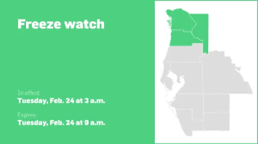
An updated cold weather advisory from the National Weather Service was issued at 1: 07 a. m. on Sunday and is valid for Monday between 3 a. m. and 10 a. m. The advisory specifically covers Pasco, Sarasota, Charlotte and Lee counties. Separate guidance flags a freeze watch for Tuesday when temperatures are expected to dip to 27.
- Sunday, 1: 07 a. m. — advisory issued
- Monday, 3 a. m. –10 a. m. — cold weather advisory window
- Tuesday — freeze watch in place; temperatures forecasted to dip to 27
- Tuesday–Wednesday overnight — inland lows fall to near freezing
What to expect tomorrow and through midweek
Tomorrow a cold front will push through with morning showers entering between 8 a. m. and 10 a. m. and wrapping up in the early afternoon. Behind the front, winds will pick up; by the afternoon temperatures will be limited to the 60s with sustained winds near 20 mph and gusts up to 30 mph. Short‑term forecasts call for first‑alert style weather days for Monday and Tuesday as highs struggle to make it out of the 50s. Long term, temperatures begin warming back up by midweek and return to near normal by Thursday.
Risk levels, definitions and practical precautions
Cold weather advisory: issued when seasonably cold air temperatures or wind chill values, but not extremely cold values, are expected or occurring. Take basic precautions — dress appropriately and cover exposed skin when venturing outdoors.
Extreme cold warning: labeled as a Take Action alert when dangerously cold air temperatures or wind chill values are expected. If you are within an extreme cold warning, avoid going outside; if you must go out, dress in layers, cover exposed skin, and make sure at least one other person knows your whereabouts and receives an update when you arrive safely.
Extreme cold watch: a Be Prepared notice when dangerously cold air temperatures or wind chill values are possible. As with warnings, adjust plans to avoid being outside during the coldest parts of the day. Practical checks include keeping your car at least half a tank of gas and updating your winter survival kit.
Local feed notes, community access and a roundup of nearby headlines
Readers should be aware that a sampling of recent comments is viewable to anyone, but contributing to conversations requires logging in or a subscription; reader conversations are opinions and subject to community guidelines. The publisher's e‑Newspaper is a digital replica of the printed paper available seven days a week on desktop, mobile and the publisher's app for subscribers only; a subscription is required to enjoy daily access. This particular weather update was produced using artificial intelligence and publicly available data, and the article template was created by the publisher. A feedback email address is listed with the bulletin.
Also appearing in the local feed: the Winter Games are winding down with notes on the final party; investor attention in the coming week will focus on fallout from a Supreme Court tariff ruling, tensions in Iran and a major technology company's fourth‑quarter earnings; mortgage and refinance coverage notes the 30‑year rate sits near three‑year lows on a popular lender marketplace; a consumer roundup highlights the top plumbing companies serving El Paso, evaluated for same‑day availability, proper licensing, Better Business Bureau accreditation and reputation; puzzle fans have hints and spoilers for Strands puzzle #721 and Wordle hints and answers are published; sports blurbs include a UCLA coast‑to‑coast victory, a note that Lakers 2026‑2027 ticket prices will reportedly rise sharply, and a recap that Jevon Carter and then Jalen Green were heroes in separate moments; consumer gear coverage flags a waterproof, windproof bestseller favored by more than 28, 000 shoppers.
What’s easy to miss is the compressed timing: showers, gusty winds, a cold advisory window and a freeze watch all arrive within a narrow span, which compresses response time for people with outdoor plans. The real question now is whether overnight inland pockets will dip below freezing early enough to affect sensitive outdoor tasks or crops.
If you’re wondering why this keeps coming up, the sequence is straightforward: a cold front brings rain in the morning, winds and colder air lower afternoon highs into the 50s and 60s, then overnight lows — particularly inland — approach freezing on Tuesday and Wednesday. Prepare to adjust outdoor plans accordingly; schedule‑sensitive activities and vulnerable outdoor assets deserve priority attention.
Copyright 2026. All rights reserved.