


Weather threat grows as blizzard warnings expand across Tri-State
A dangerous, potentially historic winter weather storm is set to slam the Tri-State area later today, bringing blizzard conditions, heavy snow, damaging winds and coastal flooding. The system will intensify through the afternoon and peak overnight, with the worst conditions expected tonight and impacts lasting into Monday morning.
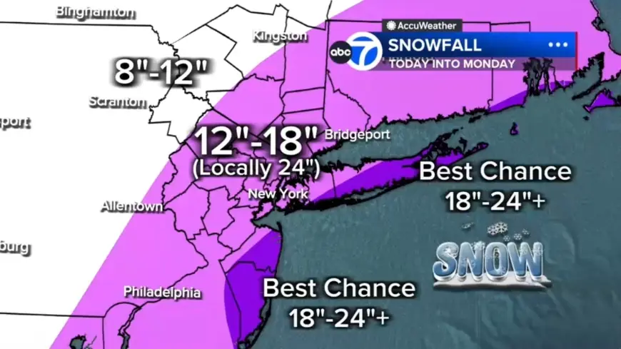
Weather threats across the Tri-State
Every county in the region is under a Blizzard Warning, and the storm is framed as the biggest snow-maker for the area since the storm of January 2016, which was the biggest snowstorm to ever hit New York City on record. The region last saw a blizzard warning in March 2017. Visibility is already reduced in spots this morning, with White Plains down to 0. 2 miles, and travel is expected to grow increasingly difficult as heavier snow organizes later today.
Heavy snow, damaging winds and coastal flooding expected tonight
After lunchtime, snow becomes more widespread and intensity increases: snowfall rates of 1 to 2 inches per hour are expected, with wind gusts 50 to 60 mph near the coast and whiteout visibility possible. Totals are forecast to pile up quickly — 12 to 18 inches across most of the region, with localized 18 to 24 inches in a central corridor from the Jersey Shore to Long Island and the best chance for 24-plus inches on the East End of Long Island and parts of the Jersey Shore. Coastal flooding is a separate threat, with up to 3 feet of coastal inundation possible around high-tide cycles tonight into Monday morning, increasing the risk to beachfront and low-lying areas.
Timing, travel restrictions and what to expect Monday morning
The strengthening coastal storm will pull up the East Coast and tap into cold air that will flip rain to snow across New York City and New Jersey by midday, with heavier bands developing by evening and the worst conditions overnight. New Jersey has issued a commercial vehicle travel restriction on multiple Interstate highways starting at 3 p. m. Sunday ET. Heavy snow is expected to continue through early Monday morning, with improving conditions by mid-morning and snow tapering during the second half of the day, though winds will remain strong and travel impacts could persist.
Roads that begin the day wet may delay initial accumulation, but that window is brief as the storm intensifies. The forecast highlights widespread power outage potential from downed trees and lines, and officials warn of rapid deterioration of conditions tonight. The next confirmed schedule point is the New Jersey commercial vehicle restriction taking effect at 3 p. m. Sunday ET; heavy snow is expected to peak overnight and begin tapering by the second half of Monday.