


UK braces for snow, ice and flooding as multiple warnings remain in place
Large parts of the country are facing a tricky mix of snow, freezing rain and flood risk this weekend as yellow weather warnings remain active. Authorities are urging people to take care on untreated surfaces and to stay alert to changing conditions as a thaw and milder air move in for some regions.
Snow and ice warnings cover wide areas
A yellow warning for snow and ice spans from Derby northwards into much of Scotland, with forecasters warning of heavy snowfall at times and the potential for significant travel delays. Snow accumulations are expected to vary with elevation: roughly 1–3 cm on lower ground, 3–7 cm above 150 metres and possibly 10–15 cm above 400 metres. Ice is an additional hazard, especially across north-east England and parts of Scotland where precipitation falling onto frozen surfaces could create very slippery conditions.
Separately, a yellow ice warning is in force for Devon and Cornwall from 12: 00 PM ET on Friday until 5: 00 AM ET on Saturday. The alert cautions that rain and sleet moving southwards could freeze as skies clear overnight, producing icy patches on untreated roads, pavements and cycle paths and increasing the risk of slips and falls.
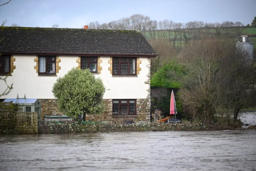
Flooding threat persists as protections and impacts tally
Flood risk remains widespread in England, with dozens of active flood warnings and many more alerts in place. Emergency teams have worked to protect properties, and authorities state that more than 24, 000 homes and businesses have been defended. Despite those efforts, around 330 properties have been inundated.
People in at-risk areas are being urged to follow local advice, avoid driving through floodwater and to move valuables to higher ground where necessary. Sandbagging and temporary defences have been deployed in several communities, and monitoring continues as rainfall and run-off combine with high river levels in some catchments.
Short-term outlook and travel advice
The immediate picture will see the wintry band easing eastwards into Sunday morning, with a brief spell of freezing rain possible in places before precipitation turns to rain and a gradual thaw begins. Sunday is forecast to start blustery for many with showery rain and some hill snow; milder air is expected to push into the south-west, with temperatures potentially reaching about 12°C in parts of Cornwall and Devon, while eastern areas remain cooler at around 4–5°C.
Forecasters expect the coming week to begin unsettled and blustery with further showers nationwide, easing by Tuesday. Another weather system may bring more unsettled conditions on Wednesday, with Thursday likely to be drier. Motorists should allow extra time for journeys, check conditions before setting out and be prepared for sudden changes, particularly on high routes and untreated surfaces. Pedestrians are reminded that even small accumulations and patches of black ice can be hazardous.
Local authorities and emergency teams remain on alert and are coordinating responses where flooding and ice present the greatest risks. Residents are encouraged to stay informed their local emergency channels, heed road closures and safety instructions, and avoid unnecessary travel while warnings are in effect.