


Friday Snowfall to Disrupt Morning and Evening Commutes
The weather forecast for Friday indicates significant snowfall that will disrupt both morning and evening commutes in Northeast Ohio. The combination of an Alberta clipper and an Arctic front is expected to create challenging travel conditions.
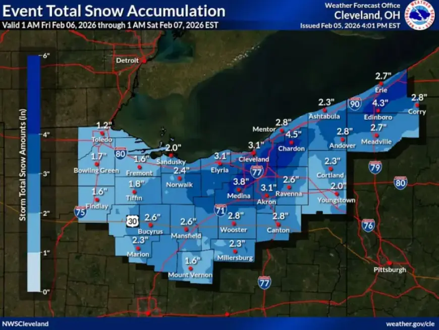
Snowfall Forecast for Friday
Light snow is anticipated Thursday night, transitioning to steadier snowfall on Friday morning. Forecasters predict that snow will accumulate between 7 a.m. and 1 p.m., impacting travel during the morning rush hour. Snowfall rates will be light to moderate, and while totals are not expected to be excessive, roads are likely to become slippery.
Afternoon Lull and Evening Deterioration
Conditions may temporarily ease Friday afternoon, but the most significant weather is expected to arrive later. Forecasts show that an Arctic front will sweep through the region late Friday, coinciding with the evening commute.
Intense Snow Squalls expected Friday Evening
The Arctic front is predicted to hit the Cleveland area between 5 p.m. and 7 p.m., moving eastward shortly after. This front may bring heavy snow showers or snow squalls, characterized by brief, intense snowfall, strong winds, and reduced visibility. Wind gusts may reach up to 40 mph, contributing to hazardous travel conditions.
Snow Totals and Weather Advisories
- Expected snowfall from Thursday night to early Saturday: 2 to 4 inches across much of Northeast Ohio.
- Localized higher totals in the snowbelt east of Cleveland.
- Winter weather advisory in effect from 7 a.m. Friday to 1 a.m. Saturday for Cuyahoga and Geauga counties.
- Predicted snowfall in these areas: 3 to 5 inches.
Cold Weather Advisory to Follow
Once the snow clears, dangerous cold temperatures will follow. Overnight temperatures on Friday night are expected to drop between 5 to -5 degrees, with wind chills plummeting to 15 to 25 degrees below zero. A cold weather advisory will be in effect from 1 a.m. to noon Saturday.
- High temperatures on Saturday: Single digits to lower teens.
- Subzero wind chills anticipated throughout the day.
This frigid weather is likely to last into Sunday morning, with a gradual warming trend expected early next week.