North Carolina weather: winter storm warning eases, cold lingers into Monday

A fast-intensifying coastal storm delivered disruptive snow and dangerous wind across parts of North Carolina and coastal Virginia through Sunday, with travel snarls and scattered power issues. By Monday, the main snow threat is expected to be over for most communities, but bitter cold, lingering slick spots, and gusty coastal conditions keep the region in a high-impact pattern.
For anyone tracking weather tomorrow, the headline is simple: clearing skies in many inland areas, but temperatures stay well below normal and any untreated surfaces can refreeze after sunset. That creates a long tail of risk even as the most intense snowfall shifts away.
Winter storm warning winds down, impacts remain
Many areas that were under a winter storm warning on Sunday are transitioning from active snowfall to cleanup and recovery. Even where new accumulation slows to flurries, conditions can remain hazardous because temperatures stay cold enough to preserve packed snow and ice.
The second part of the hazard is wind. Strong gusts can keep blowing snow around open areas and reduce visibility at times, especially in exposed locations. In the mountains and foothills, strong winds also raise the chance of isolated tree damage where snow loading occurred.
Snow totals NC: where the heaviest fell
Snow totals NC varied sharply, with some communities picking up only a few inches while others saw near-record amounts for this time of year. In west-central and eastern parts of the state, totals climbed into the double digits in spots, while the Charlotte area saw significant accumulation that contributed to widespread travel disruptions.
For drivers, the practical takeaway is that totals matter less than road treatment and timing: shaded stretches, bridges, and ramps can stay icy well after plows move through. If you’re planning errands or a commute, assume patchy slick spots remain into Monday morning—particularly on secondary roads.
North Carolina weather: what changes Monday
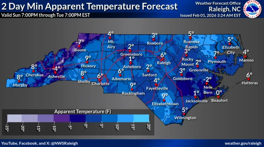
Monday’s pattern shifts toward drier air and more sunshine for much of the interior. That helps, but it doesn’t melt much when the sun angle is low and temperatures top out in the 30s and 40s. Expect a “looks better than it feels” day: improved visibility and fewer falling flakes, but a persistent bite to the air.
Overnight refreeze remains the key concern. Any melting that does occur during daylight can re-ice quickly after dark, so conditions late Monday evening can be trickier than midday.
Weather tomorrow: Charlotte and Raleigh outlook
For charlotte nc weather, Monday looks cold with intervals of sun and clouds. High temperatures are expected to reach the low 40s, with a hard freeze Monday night. Even if streets look mostly clear, watch for compacted snow near curbs, in parking lots, and on untreated neighborhood roads.
For raleigh weather and weather raleigh nc, Monday is expected to be similarly cold, with sunshine mixing with clouds and highs also near the low 40s. The bigger issue is the overnight freeze; any leftover moisture from plowing, slush piles, or melting during the day can turn slick again after sunset. If you’ve been tracking raleigh nc weather updates, keep an eye on school and government schedules tied to road treatment progress.
Virginia Beach weather: wind and coastal flooding
For virginia beach weather and weather virginia beach, the snow risk is lower than farther inland, but the coastal hazards are higher. Sunday’s strongest impacts centered on high winds, rough surf, and coastal flooding risk in low-lying areas near tidal waterways. Monday stays windy and cold, with clouds lingering and temperatures struggling into the mid 30s.
If you’re monitoring weather virginia beach for Monday travel, plan for reduced comfort and possible lingering water on vulnerable roads near the waterfront, even as the worst surge-related impacts fade.
Forecast snapshot for Monday (ET)
| Location | Monday high / low | What to watch |
|---|---|---|
| Charlotte, NC | 43°F / 17°F | Refreeze on untreated roads |
| Raleigh, NC | 43°F / 19°F | Icy patches after sunset |
| Asheville, NC | 38°F / 14°F | Cold plus lingering mountain slick spots |
| Virginia Beach, VA | 36°F / 25°F | Windy, leftover coastal impacts |
Blizzard and snowfall: coastal hazards continue
While a true blizzard setup is limited to the most exposed coastal zones, the combination of wind and heavy snow created near-whiteout bursts in some areas during the height of the storm. Even as skies improve inland, the coast can remain volatile: strong gusts, rough surf, and beach erosion potential can linger after the last meaningful flakes fall.
Bottom line: Monday is a transition day—better than Sunday, but not “back to normal.” Treat it like a cold-weather cleanup day, and assume slick spots persist where snow was deepest or treatment is slow.
Sources consulted: National Weather Service, Reuters, WRAL Weather, WAVY 10 Weather


