


Bomb cyclone 2026 threat builds as a weekend nor’easter targets the East Coast and Arctic cold reaches the Gulf Coast
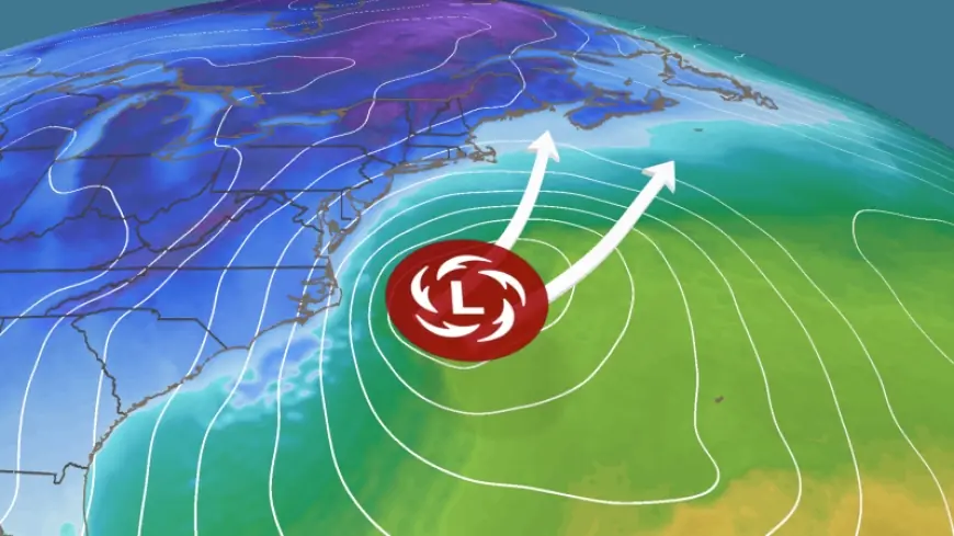
A bomb cyclone setup is drawing attention heading into the upcoming weekend, as forecasters track a fast-strengthening coastal storm that could evolve into a nor’easter with heavy snow, damaging winds, and coastal flooding potential along parts of the U.S. East Coast. As of Wednesday, January 28, 2026, ET, the main uncertainty is the storm’s exact track and where the sharp rain-snow line sets up, a detail that can shift meaningful impacts by dozens of miles.
At the same time, a broader Arctic outbreak is pushing unusually cold air deep into the South, including the Gulf Coast of the United States, making freeze conditions and wind chills a parallel concern even in places that may not see snow.
What a bomb cyclone is and why it can feel like a “winter hurricane”
A “bomb cyclone” is not a different type of storm so much as a label for how rapidly a storm intensifies. Meteorologists call the process explosive cyclogenesis: an extratropical low-pressure system deepens dramatically in a short window. The classic benchmark is a central pressure drop of about 24 millibars in 24 hours near 60 degrees latitude, with the threshold adjusting by latitude. When that pressure plunges, the storm’s pressure gradient tightens, and winds can ramp up quickly.
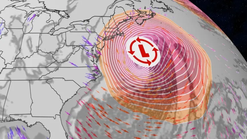
Mechanically, bombogenesis typically happens when cold, dense air collides with warmer, moisture-rich air along a strong jet stream. The ocean supplies heat and water vapor, rising air condenses into clouds and precipitation, and that release of latent heat helps the storm deepen further. The result can be a sprawling system that produces heavy snow inland, sheets of rain and thunder nearer the coast, and powerful onshore winds that pile water into vulnerable shorelines.
The weekend nor’easter: snow, wind, and coastal flooding depend on the track
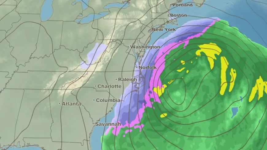
Forecast guidance points to a coastal low developing and intensifying rapidly as it lifts north along the Atlantic seaboard during the weekend of January 31 to February 1, 2026. The strongest impacts are most likely near the coast, where wind, waves, and surge-driven flooding can become the primary hazards even if snow totals vary.
Snow potential typically rises on the northwest side of the storm, where colder air is entrenched and precipitation rates can be intense enough to overcome marginal temperatures. If the system strengthens quickly, bands of heavy snow can develop with reduced visibility, while the coastal plain can end up closer to a rain-sleet mix if warmer air noses in aloft. A full public timeline has not been released detailing which specific metro corridors will be most likely to see the heaviest snow bands because confidence hinges on the final storm track.
Some specifics have not been publicly clarified, including the storm’s eventual minimum pressure and whether it will meet bomb cyclone criteria at the point of peak intensification.
Gulf Coast outlook: bitter cold, freezes, and the “snow next weekend” question
Along the Gulf Coast, the more immediate story is cold rather than a classic snowstorm signal. Forecasts for key Gulf cities show a sharp drop heading into the weekend, with subfreezing lows possible even near the coast. For Saturday, January 31, New Orleans is expected to top out near the low 40s with a low in the mid 20s, while Houston’s high is forecast in the mid 40s with a low in the upper 20s. Mobile and Pensacola look even colder, with highs in the upper 30s and overnight lows near the upper teens. Tampa is forecast to turn sharply cooler with lows near the low 30s into Sunday.
So, will there be snow next weekend on the Gulf Coast? Based on the current temperature and precipitation signals in the near-term outlook, widespread snow along the immediate coastline looks unlikely, but the cold air is real and could allow brief wintry mixes farther inland if moisture arrives at the right time. Further specifics were not immediately available on any localized snow potential away from the coast because even a small shift in timing of rain relative to the coldest air can change the outcome quickly.
Who is affected and what to do before conditions deteriorate
The stakeholder impact spans multiple groups. Coastal residents and businesses from the Mid-Atlantic to New England face the risk of power outages, beach erosion, and hazardous travel if winds and waves peak near high tide cycles. Drivers and travelers could run into rapidly changing road conditions where snow bands set up, while air travel often sees ripple delays when wind and de-icing demand climb at major hubs. On the Gulf Coast, households and property managers should prepare for hard freezes that can burst pipes, stress heating systems, and threaten pets and sensitive plants, while utilities must balance cold-driven demand spikes with any wind-related disruptions.
Practical steps are straightforward: keep phones charged, have a flashlight and batteries, plan for at least a day of reduced travel flexibility, and in freeze-prone areas protect exposed pipes and know how to shut off water if needed. If you live near the ocean, treat coastal flood advisories seriously and avoid walking near jetties and seawalls when surf is high.
The next verifiable milestone will be the National Weather Service forecast updates in the Friday, January 30, 2026, ET cycle, when storm-track confidence typically tightens enough to support winter storm watches, coastal flood products, and more specific snow and wind timing guidance.