


Boston weather forecast: extreme cold gives way to a high-impact snow window that could snarl travel into Monday night
Boston’s forecast through Monday isn’t just “winter weather” — it’s a two-part disruption that escalates from safety risk to mobility risk. Saturday’s bitter cold can become dangerous quickly with wind chill, especially for anyone outdoors for more than a few minutes at a time. Then the bigger problem arrives Sunday into Monday: a warning-level snow event with strong gusts that can cut visibility, slow plowing progress, and turn routine trips into long, unpredictable delays. The overlap with early-week commuting hours is the pressure point.
Risk and uncertainty: why this storm could feel worse than the final snowfall number
The headline totals matter, but Boston storms often hinge on three less-glamorous factors: timing, wind, and surface temperature.
-
Timing: Snow beginning Sunday and continuing into Monday means roads and transit are stressed when demand is highest.
-
Wind: Gusts can push snow back onto treated lanes and create drifting, making cleared streets slippery again.
-
Cold ground: When temperatures are very low, road treatment can be less effective, and refreezing can outlast the snowfall itself.
That combination creates uncertainty that drivers and commuters actually feel: not “how many inches,” but how consistent the traction is and whether visibility collapses in bursts. In banded snow, one part of the city can be manageable while another becomes a crawl, and that unevenness complicates travel decisions.
The forecast details: cold today, snow Sunday into Monday, and a slow cleanup after
Saturday (Jan. 24) stays mostly dry but harsh. Daytime highs are expected to hover in the teens, with single digits possible overnight. Wind chill can push “feels like” values below zero at times, turning short waits at bus stops, platforms, or curbside pickups into real cold-stress situations.
The pattern shifts Sunday (Jan. 25) as snow spreads in and intensifies later in the day. The most disruptive stretch is expected from Sunday afternoon through Sunday night, when snowfall rates can be heavy enough to reduce visibility and quickly coat untreated surfaces. Snow continues into Monday (Jan. 26), with conditions remaining difficult until the system tapers late day or evening.
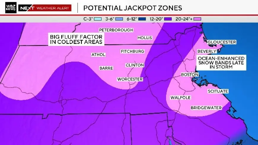
A winter storm warning window is posted for the region from Sunday morning through Monday evening, with projected heavy snow totals in the low-to-upper teens (inches) in the hardest-hit areas and gusts around the mid-30 mph range. Even where totals run lower, the wind can keep conditions rough by lowering visibility and drifting snow across lanes.
Mini timeline (Eastern Time)
-
Sat, Jan. 24: Dry but dangerously cold; wind chill can be below zero at times.
-
Sun, Jan. 25 (morning): Snow begins to develop; travel starts to deteriorate.
-
Sun, Jan. 25 (afternoon → night): Heavier snow and lower visibility in bursts; conditions can worsen quickly.
-
Mon, Jan. 26: Snow continues; gusty periods keep roads messy and slow the clearing pace.
-
Mon, Jan. 26 (evening): Snow tapers, but slick surfaces and narrowed lanes can linger into the night.
Where the disruption tends to show up first
-
Bridges, overpasses, and ramps: faster icing and sudden loss of traction.
-
Side streets and bus routes: slower clearing, tight turns, and snowbanks that squeeze lanes.
-
Air travel and rail schedules: delay cascades build when many trips get rescheduled into the same limited windows.
Boston’s forecast is essentially a weekend squeeze: Saturday punishes exposure, Sunday and Monday punish movement. If plans are flexible, compressing errands into daylight Saturday (and keeping Sunday afternoon/evening clear) reduces the odds of getting caught in the worst combination of heavy snow, wind, and cold surfaces that don’t improve quickly once the flakes stop.


