


Weekend Begins Warm, Ends with Cool Temperature Shift
As the weekend approaches, South Florida is set to experience a dynamic shift in weather. The forecast highlights a warm Saturday followed by a significant cool-down starting late Sunday.
Weekend Weather Overview
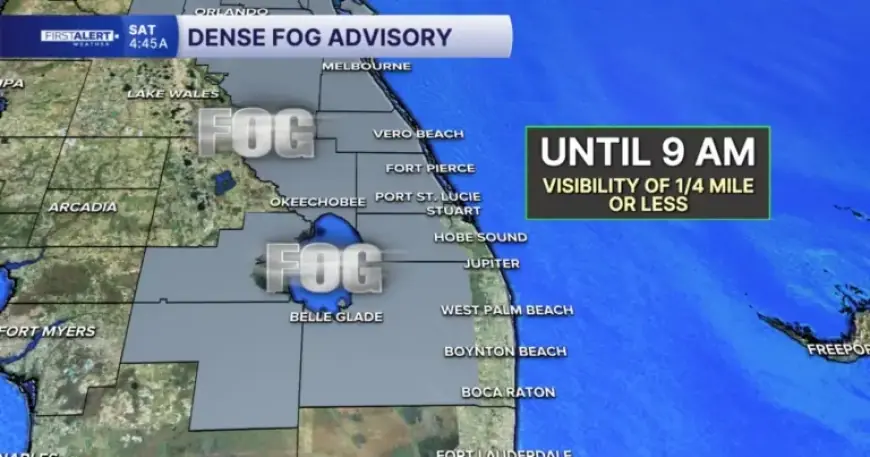
Patchy fog has developed in the early morning hours, particularly affecting inland areas of Okeechobee County and the interior Treasure Coast. Visibility could drop to a mile or less, prompting drivers to exercise caution and maintain safe distances.
By mid-morning, the fog is expected to dissipate, making way for warmer temperatures. Highs for the day are predicted to reach the upper 70s to low 80s. Inland regions may see temperatures rise into the mid to upper 80s, accompanied by light winds and a sea breeze along the coastline. A few stray showers might occur near the Treasure Coast, but most areas should remain dry.
Sunday Forecast: Warm and Record-Breaking Potential
Sunday will feel particularly warm for January, as brisk southerly winds elevate temperatures. Highs are anticipated to climb into the mid to upper 80s across inland areas. Coastal regions may experience lower to mid 80s. Notably, some locations away from the ocean could approach or even surpass daily record high temperatures.
However, afternoon winds may become gusty, reaching up to 25 mph. Beachgoers should be cautious, as a high risk of rip currents persists at all Atlantic beaches, making swimming highly discouraged due to hazardous conditions.
Weather Transition: Cold Front Arrival
Late Sunday night into Monday, a strong cold front will sweep through South Florida, bringing scattered showers. Fortunately, no thunderstorms are forecasted. Following the frontal passage, winds will shift to the northwest, leading to a dramatic drop in temperatures.
- Monday afternoon highs across the Treasure Coast will be in the upper 60s to low 70s.
- The Palm Beaches may experience highs in the upper 70s.
- Cooler air will settle in Monday night into Tuesday morning.
Midweek Preview and Continued Cold Stretch
High pressure will dominate the region, ensuring dry conditions through the middle of the week. However, temperatures will remain notably below normal. Tuesday’s afternoon highs are expected to hover in the middle to upper 60s. A subsequent cold front late in the week could prolong the chilly weather, with early mornings potentially dropping into the 40s alongside lingering concerns for near-freezing conditions inland.