


Boston weather turns from dangerous cold to a high-impact snowstorm — and the Monday commute is in the crosshairs
Boston’s weather over the next 48–72 hours isn’t just “wintery” — it’s the kind that changes daily routines fast. Saturday (Jan. 24) brings brutal cold that can become a safety issue in minutes, especially with wind. Then the bigger disruption arrives: a Winter Storm Warning window from Sunday morning (Jan. 25) through Monday evening (Jan. 26) with heavy snow and gusty winds that can snarl roads, ground flights, and stretch travel times far beyond what the snowfall totals suggest. Here’s the part that matters: the worst timing overlaps the region’s highest-demand travel periods.
The immediate impact: cold stress today, travel stress tomorrow
Saturday is the “short exposure” day — the kind where a quick errand can become a problem if you’re underdressed or stuck waiting (bus stops, platforms, curbside pickups). Expect very cold temperatures with a high near 15°F (-9°C) and low near 7°F (-14°C). Wind makes it feel worse, and frostbite risk rises with longer exposure.
Then the storyline flips from cold hazard to mobility hazard:
-
Sunday into Monday: heavy snow builds and visibility drops in bursts.
-
Wind gusts: can push snow back onto treated surfaces and reduce traction even after plows pass.
-
Road treatment limits: when it’s cold enough, salt becomes less effective, so slick spots linger longer.
It’s easy to overlook, but the biggest disruptor is rarely the “headline snowfall number.” It’s the combination of timing + wind + temperature that turns normal traffic into stop-and-go gridlock.
What the forecast is calling for, and when it sharpens
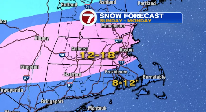
Official alerts in the Boston area indicate a Winter Storm Warning from 7:00 AM Sunday to 8:00 PM Monday (Eastern Time), with total snow accumulations roughly in the 13–19 inch range in the hardest-hit zones and wind gusts up to about 35 mph. Snow can fall in heavier bands, which is why two neighborhoods can look like different cities by the end.
A practical way to think about it is in phases (times are Eastern Time; for readers in Cairo, add 7 hours):
-
Saturday, Jan. 24: Mostly sunny but dangerously cold (high ~15°F / low ~7°F).
-
Sunday, Jan. 25 (morning → afternoon): Snow develops and intensifies; travel conditions start deteriorating quickly.
-
Sunday night: Highest risk for heavier snowfall rates and poor visibility in bursts.
-
Monday, Jan. 26: Snow continues, then tapers later; cleanup is slowed by cold and drifting.
-
Monday evening: The warning window ends, but slick roads and narrowed lanes can persist.
The real test will be how fast crews can keep up during the heavier bands and whether wind-driven drifting keeps re-covering freshly cleared surfaces. That’s what determines whether a “bad commute” becomes an “avoid-the-roads” day.
A quick reality-check list before you get caught out
-
If you must drive: plan for slower speeds, extra stopping distance, and the possibility that side streets stay messy longer than main routes.
-
If you’re flying: expect knock-on delays and rolling cancellations; rebooking can get tight when many travelers pivot at once.
-
If you’re walking: watch for black ice near intersections, curb cuts, and around melted-and-refrozen patches.
-
If you’re parked on the street: be ready for shifting rules and access issues as snowbanks build.
Boston weather this weekend isn’t subtle: Saturday challenges your tolerance for cold; Sunday and Monday challenge your ability to move around the city on time. If you can shift plans earlier in the day Sunday — or compress errands into Saturday afternoon — you’ll likely save yourself the worst of the squeeze.


