


Winter Storm to Impact South Carolina This Weekend: First Alert Issued
The National Weather Service has announced an Ice Storm Warning for several counties in South Carolina due to an impending winter storm. The warning is in effect from 1 PM today through 1 PM on Monday. Areas affected include Saluda, Newberry, Fairfield, Kershaw, Richland, Lexington, Calhoun, and Sumter counties.
Winter Storm Impacting South Carolina This Weekend
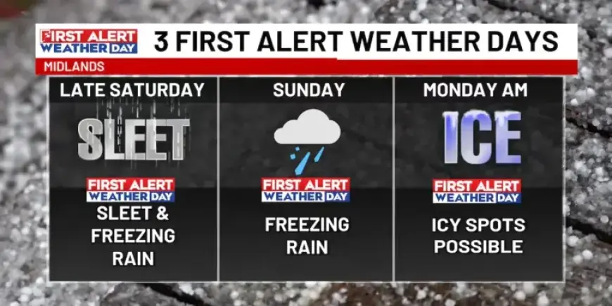
In addition to the Ice Storm Warning, a Winter Weather Advisory is also active for southern regions, specifically Orangeburg and Clarendon counties, during the same time frame. The winter storm will introduce three First Alert Weather Days, commencing this evening.
Forecast and Expected Conditions
Current indications suggest that the weather today will remain predominantly dry, with cloudy skies and temperatures peaking in the low 40s. As the system approaches, light sleet is expected to start this evening, marking the onset of the hazardous weather.
- Tonight: An 80% chance of freezing rain, particularly in northern areas near I-20.
- Temperature: Mid 20s, with liquid precipitation freezing on contact.
- Travel Warning: Risk of slick spots on roads and sidewalks due to ice buildup.
The freezing rain will likely intensify Sunday morning, leading to the highest ice accumulations of the storm. Subsequently, a weather front could generate thunderstorms later that day, resulting in over an inch of rain.
Week Ahead Weather Outlook
The First Alert Weather Day will extend into Monday morning as temperatures are expected to drop to freezing. This may cause any remaining surface water to freeze, creating additional travel hazards. A general overview of the upcoming week’s weather is as follows:
| Day | Weather | High Temperature |
|---|---|---|
| Today | Cloudy, mix of rain and sleet | Upper 30s |
| Sunday | Freezing rain transitioning to liquid rain | Upper 30s |
| Monday | Morning ice, clearing skies | Low 40s |
| Tuesday | Sunny, cold start | Low 40s |
| Wednesday | Crisp mornings, warmer afternoons | Upper 40s |
Residents are advised to stay informed and take precautions due to possible hazardous conditions this weekend. Regular updates will be provided as more information becomes available from the National Weather Service.