Detroit Weather Update: Winter Alerts, Wind and Blizzard Warning Terms Explained, and the Snowfall Forecast That Could Affect Rush Hour
Detroit’s weather pattern is shifting into a high-impact cold stretch, with bitter temperatures and wind chills becoming the main hazard as the metro heads toward the weekend. While “winter storm warning,” “wind advisory,” and “blizzard warning” are the phrases most people search during active winter weather, the headline for Detroit right now is extreme cold and wind chill—plus a growing chance for accumulating snow late Saturday night into Sunday that could create slick travel and delays.
Detroit weather alerts: what’s actually in effect for the city
For Detroit and the immediate metro, the primary active headline is a Cold Weather Advisory beginning early Friday and running into Saturday morning. That advisory focuses on dangerously low wind chills—the kind of cold that can create frostbite risk on exposed skin and strain vehicles, batteries, and vulnerable plumbing.
A key point: Detroit is not currently under a blizzard warning, and the presence of winter headlines elsewhere in the Great Lakes doesn’t automatically mean the city is in the highest tier of storm impacts. In Southeast Michigan, winter alerts can vary sharply by county based on lake-effect positioning, wind direction, and temperature profiles.
Wind advisory vs. “breezy”: why the wind still matters in Detroit
Even without a wind advisory posted for the city itself, gusty winds are still part of the story. When temperatures plunge into the single digits (or below), even a modest breeze can drive wind chills well below zero. That’s why the practical impacts for Detroit commuters are less about “how windy” it feels and more about what the wind does:
-
Drops wind chill fast on platforms, sidewalks, and parking lots
-
Increases the chance of patchy blowing snow where powder is on the ground
-
Turns minor flurries into visibility issues on open stretches of freeway
Snowfall weather forecast for Detroit: when flakes matter most
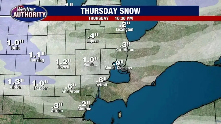
Detroit’s short-term setup is a cold, mostly quiet window punctuated by light snow chances, followed by a more meaningful snow signal late weekend.
Here’s the metro-level trend most residents will notice:
-
Thursday: Cloudy and breezy with flurries; a slick spot is possible where brief bursts occur, but widespread accumulation isn’t the main issue.
-
Friday into Saturday: Frigid with the harshest wind chills; snow is limited, but any untreated moisture can refreeze quickly.
-
Late Saturday night into Sunday: Snow chances increase, with snow becoming more likely Sunday. Even a moderate accumulation can cause disproportionate travel impact because pavement temperatures will be very cold.
-
Early next week: Periodic snow chances remain possible, but the day-to-day totals will depend on how bands set up and whether lake-enhanced snow reaches the metro.
Rush hour: what to expect for Detroit commuters
Detroit’s winter travel problems often spike when light snow combines with very cold pavement—because the first thin layer bonds quickly and salt can take longer to work.
Thursday evening rush hour
-
Watch for brief snow showers and gusts that can reduce visibility in bursts.
-
Bridges and overpasses cool faster and can ice first.
Friday morning rush hour
-
The most immediate risk is exposure: bundled commuters, kids at bus stops, and anyone dealing with a stalled car faces dangerous wind chills.
-
Roads may look fine, but black ice can linger in shaded spots and on ramps if any moisture refreezes overnight.
Sunday evening into Monday morning (potentially higher-impact window)
-
If Sunday’s snow verifies, expect slower travel, reduced traction, and a higher chance of minor crashes during peak traffic hours.
Blizzard warning and winter storm warning: what they mean, and why Detroit may still hear those words
These terms are frequently used as shorthand for “bad winter weather,” but they have specific meanings:
-
Winter Storm Warning: Significant snow and/or ice is expected soon or is occurring, typically capable of making travel dangerous.
-
Blizzard Warning: Not just heavy snow—this is about visibility. Blizzard conditions require sustained/frequent gusty winds plus falling/blowing snow that drops visibility to very low levels for hours.
Detroit can feel “blizzard-like” during brief squalls, but a true blizzard warning is reserved for prolonged, widespread near-whiteout conditions. If a stronger system aligns with powdery snow and higher winds, then the language can escalate quickly—especially in open areas and along lake-influenced corridors.
What to do now in Detroit
-
Plan for the cold first: Charge devices, check car batteries, keep a warm layer in the vehicle, and protect exposed plumbing if your home is vulnerable.
-
Treat Sunday as the snow pivot: If you have flexible travel plans, Sunday is the day most likely to turn into a slower-drive scenario.
-
Commute strategy: Leave extra following distance, avoid sudden braking, and assume ramps/overpasses are worse than surface streets.
Detroit winter weather can change fast with subtle shifts in wind and storm track. The smartest move is to treat the next 48 hours as an extreme-cold event, then shift focus to snow timing and totals as Sunday approaches.
