


Showers and Warmer Temperatures Expected Wednesday
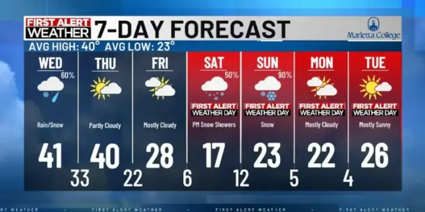
As the Mid-Ohio Valley prepares for changing weather conditions, showers and warmer temperatures are expected on Wednesday. A front passing through the region will bring some rain, with temperatures reaching the low 40s. Snow may make a brief appearance but will likely give way to rain as temperatures rise. This shift marks a short reprieve from the cold weather affecting the area.
Forecast for Wednesday
Showers are anticipated to pass through the Mid-Ohio Valley early Wednesday afternoon. Rain is expected to conclude by late evening, leading to calmer weather on Thursday and Friday. However, the focus is shifting toward a potential winter storm that may impact the region over the weekend.
Key Points to Consider
- Timing: Snow is predicted to begin Saturday night and could continue into Sunday.
- Impacts: The primary concern is accumulating snow and frigid temperatures, which may lead to travel difficulties, particularly southward.
- Forecast Uncertainty: While there is some unpredictability regarding snow amounts, models suggest a chance of moderate to heavy snowfall is increasing.
- Temperature Drop: Lows might plunge below 10 degrees overnight from Friday into Tuesday. Wind chills could fall even lower, possibly below zero.
As the weekend approaches, updates on the temperature forecast are likely. Residents are encouraged to prepare for another round of arctic air and potential winter weather impacts in the Mid-Ohio Valley. For the latest updates, stay tuned to Filmogaz.com.