


Winter Storm Targets DMV: Latest Updates on Snowfall and Timing
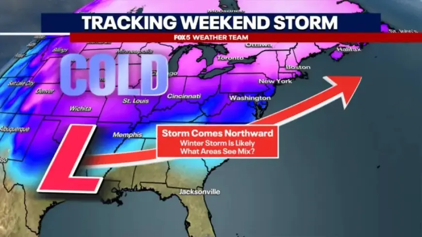
Winter weather is poised to impact the DMV area over the weekend. Forecasts indicate significant snowfall beginning Saturday night and continuing into Sunday. Meteorologists are closely monitoring several models to determine the storm’s trajectory and impacts.
Snowfall Timeline and Intensity
The cold front will usher in frigid temperatures on Saturday morning, resulting in a dry day before the snow begins to fall. Initial flakes may start between 8 p.m. Saturday and midnight. As the snow arrives, models predict rapid intensification overnight, possibly reaching rates of 1-2 inches per hour.
Projected Snowfall Amounts
Current models suggest major accumulations in the region. The American model estimates 10-17 inches across the D.C. area, while the European model presents a slightly lower range due to expected mixing with sleet and freezing rain. Here’s a summary of potential snowfall by region:
- Washington D.C.: 8-14 inches
- Southeast regions: 5-10 inches
- Northwest areas: 12-18+ inches
Concerns About Mixing
While heavy snowfall is anticipated, there is concern regarding the possibility of warmer air infiltrating the upper atmosphere. This could lead to sleet or freezing rain, particularly in the I-95 corridor. Weather teams are monitoring this closely as it could influence final snowfall totals.
Post-Storm Conditions
After the storm exits late Sunday night into early Monday, temperatures are forecasted to drop dramatically, potentially plunging into the teens. This freeze will create hazardous travel conditions due to icing, limiting the effectiveness of road treatment chemicals.
Future Monitoring and Updates
Weather agencies, including NOAA and the National Weather Service, are actively gathering data to refine forecasts. They are employing specialized Hurricane Hunter missions to better sample the storm system. Updates will continue throughout the weekend as new data becomes available.
Be prepared for potentially dangerous winter weather conditions as this storm unfolds. Regular updates will help ensure safety and accurate information on snowfall and travel advisories.