


Snow Accumulation and Hazardous Wind Chills to Hit Metro Detroit
Metro Detroit is bracing for a significant weather shift. Snow accumulation and hazardous wind chills are expected over the coming days, impacting the region’s conditions.
Weather Forecast Overview
This Sunday will begin under mostly cloudy skies with a high of 23°F. Snow is anticipated to develop on Sunday evening, leading to overnight accumulations of 1 to 3 inches. The temperature is expected to drop to 17°F at night.
Monday: Snow Showers and Hazardous Winds
On Monday, the day will start with cloudy conditions and a chance of snow showers. Accumulations from these snow showers could add to the totals from Sunday night. The high will reach only 21°F, but gusty winds are forecast throughout the day.
- Wind gusts are expected to reach 30-35 MPH, potentially hitting 40 MPH.
- Wind chills may plunge into single digits and even below zero.
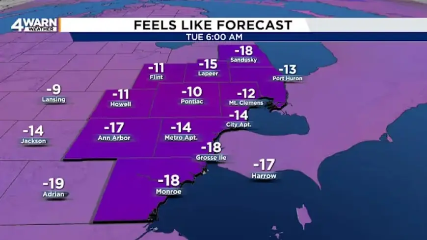
As Monday night arrives, temperatures will fall to around 4°F, with wind chills as low as -10°F to -15°F.
Continued Cold and Snow Chances
Tuesday will remain mostly cloudy and cold, with a high of only 15°F. A chance of snow may develop later in the evening, lowering temperatures to around 8°F. The following days show a slight warming trend, with highs projected in the mid to upper 20s on Wednesday and Thursday.
Looking Ahead
The forecast indicates no significant snow chances until next weekend. Snow could return on Saturday with temperatures warming to the upper teens. The conditions will remain dry with low temperatures dropping into the single digits.
Residents of Metro Detroit should prepare for hazardous wind chills and snow accumulation as they navigate this wintry weather ahead.