


Severe Wind and Fire Threat Looms Over Kansas This Friday
Severe wind and fire threats are expected to impact Kansas this Friday. Residents should be prepared for challenging weather conditions as an Arctic cold front moves across the state.
Current Weather Conditions
This morning, temperatures across Kansas are quite chilly, ranging from the teens to the 20s. With light winds, the wind chill makes it feel even colder. However, temperatures are expected to rise slightly later today, reaching highs between 50 and 60 degrees under mostly sunny skies.
Forecast for Friday
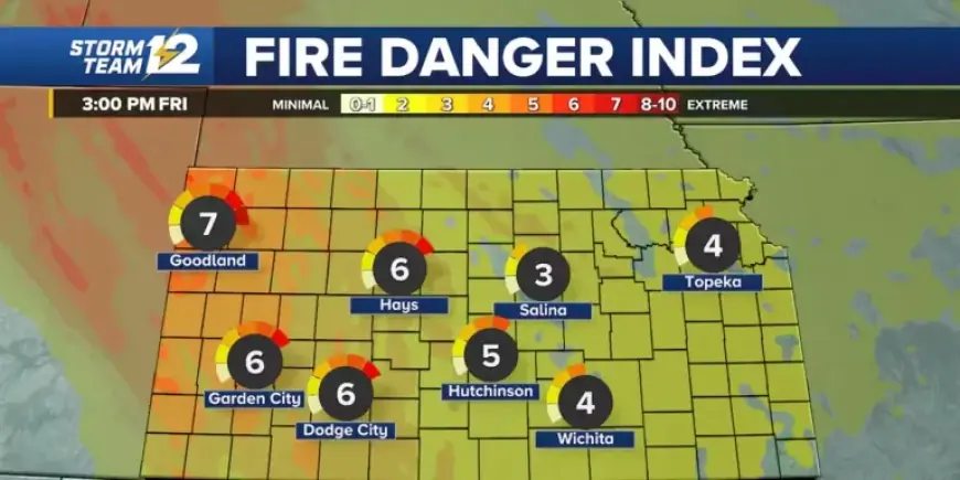
As the cold front approaches tonight, temperatures will drop into the 30s and 40s. The primary concern for Friday is the strong wind, particularly in western Kansas, where gusts may reach between 50 and 60 mph. These winds will elevate the risk of fire due to critical fire weather conditions.
Additional Weather Outlook
Some flurries may occur tomorrow afternoon into the night, but no significant snow accumulation is anticipated. Saturday’s weather will start cold, with wind chill temperatures feeling like single digits and teens, while daytime highs will only reach the 20s and 30s. On Sunday, milder temperatures in the 40s are expected with less wind.
Weekly Outlook
- Saturday: Low of 20, high of 29. Mostly sunny and cold.
- Sunday: Low of 15, high of 43. Sunny and breezy.
- Monday (Martin Luther King Day): Low of 20, high of 35. Sunny with colder temperatures.
- Tuesday: Low of 19, high of 47. Sunny and breezy with a slight warm-up.
- Wednesday: Low of 27, high of 42. Mostly sunny but cooler conditions.
Residents are encouraged to stay informed of the weather changes, particularly on Friday, due to the severe wind and fire threat. Stay safe and prepared in the face of these changing conditions.