


Power Outage Threat Intensifies as Nor'easter Brings Blizzard Conditions and Widespread Heavy Snow to Southern New England
Power Outage risk is rising as a Nor'easter slams Southern New England with crippling snow and damaging wind gusts. Blizzard conditions have blanketed the region this Monday morning and are expected to persist through the height of the storm, creating nearly zero visibility, impassable roads, and a strong threat of downed tree limbs and electrical wires.
Power Outage Risk and Likely Areas
The combination of heavy, wet snow and powerful northeasterly wind gusts is increasing the likelihood of power outages. Wet, high-water-content snow weighs more than earlier storms this season, elevating the chance of tree damage that can bring down power lines. Gusts of 50–70 mph are expected through Monday afternoon, with gusts of 60 mph or more especially threatening along the south coastline; those coastal areas are called out as especially vulnerable to outages.
- Snow type: wet, heavy, higher water content than prior storms.
- Wind gusts: 50–70 mph expected through Monday afternoon; 60+ mph gusts increase outage risk along the south coastline.
- Primary mechanism: heavy wet snow plus high winds causing downed tree limbs and wires.
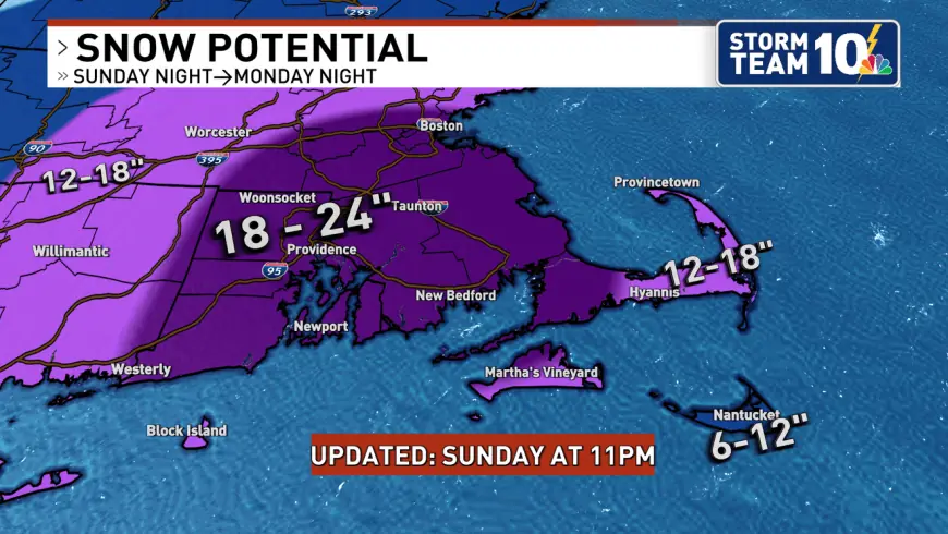
Storm Timeline, Snowfall and Travel Impact
Blizzard conditions have reduced visibility to near zero at times and will continue for multiple hours. The heaviest snow is ongoing through Monday morning, with intense snowfall rates of 2–3 inches per hour possible and isolated pockets of thundersnow. Snowfall totals have increased for much of the region as the storm track takes the system close to benchmark conditions for a major event.
Forecasted accumulations are substantial across Southern New England: a widespread 18 to 24 inches is expected across most of Rhode Island and southeastern Massachusetts, while the immediate south coast and areas toward the Cape Cod canal are expected to see 12 to 18 inches. Heavy snow and strong gusts are expected to make travel impossible in many areas; road conditions are forecast to deteriorate rapidly and could become impassable by Monday morning.
Snow intensity may begin to ease later in the day, with snowfall rates potentially letting up around 3 PM ET, though light to moderate snow could linger until roughly 11 PM ET. The worst of the storm may be over by sunset Monday, but significant impacts on roads and infrastructure are expected to persist while cleanup and restoration occur.
What Residents Should Expect and Do Now
Expect major disruption to travel and the potential for localized or widespread outages. Residents in vulnerable areas, especially along the south coastline, should prepare for temporary loss of power and plan accordingly. The heavy snow will require time to clear safely; if clearing driveways and walkways, make multiple passes with shovel, plow, or snowblower to manage the heavy accumulation.
Given the blizzard conditions and near-zero visibility, travel is strongly discouraged and should be considered impossible in affected zones. The scale of expected snowfall and the high winds combine to create a multi-faceted hazard: deep snow, drifting, downed limbs and wires, and prolonged interruptions to transportation and utilities.
This remains a fast-moving situation; details may evolve as the storm progresses and conditions change. Residents should follow local public safety guidance and prioritize safety when making decisions about travel and outdoor activity.