


Freeze Watch Issued Across Central Florida as Arctic Blast Drives Temperatures Below Freezing
A broad freeze watch and multiple cold-weather alerts have been activated across Central Florida after a cold front pushed through, and emergency actions are being recommended as dangerously low wind chills develop. The freeze watch arrives amid gusty, dry conditions that have already triggered fire-weather warnings and prompted closures of area water parks.
Cold front timing and the Sunday-to-Tuesday temperature timeline
The cold front moved through Central Florida Sunday morning and is expected to clear the region by mid-afternoon, with showers tapering off around 1–2 p. m. Sunday. Temperatures before the passage reached the mid to upper 70s, then plunged Sunday night into the middle to upper 30s. Monday morning is forecast to start in the 30s and 40s with wind chills falling into the 20s and 30s; highs Monday afternoon will only reach the lower to middle 50s. Monday night into early Tuesday is expected to be the coldest stretch, with metro lows in the lower to middle 30s and some northwest-of-Orlando spots slipping into the upper 20s or below.
National Weather Service Freeze Warning for Orlando, Kissimmee and neighboring cities
The National Weather Service has issued a freeze warning for Tuesday from 3 a. m. to 9 a. m. covering cities that include Celebration, Orlando, Kissimmee, Oviedo and Clermont. During that window the weather service estimates sub-freezing temperatures as low as 30 degrees are possible. A Cold Weather Advisory is also in effect from 3 a. m. to 9 a. m. Monday to highlight dangerously cold feels-like temperatures during the morning commute.
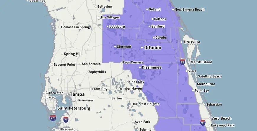
Freeze Watch for Marion, Sumter, Flagler and FOX 51 counties
A freeze watch goes into effect Monday night into Tuesday for multiple counties. Freeze watches have been issued for Marion, Sumter and Flagler counties, as well as FOX 51 locales in Alachua, Levy and Gilchrist counties. The freeze watch complements other local advisories anticipating wind chills in the mid to upper 20s, and the forecast warns residents to cover plants and bring pets inside.
Red Flag Warning and Fire Weather Watch tied to gusty winds and low humidity
Gusty winds combined with very low humidity have already prompted a Red Flag Warning and a Fire Weather Watch in parts of the area, heightening brush-fire risk. Officials warn that outdoor burning is not advisable while the dry air persists; this follows a continuing drought that forecasters say will not be materially eased by the scattered Sunday showers and a few downpours.
Impact on parks, travel and community operations
Cold conditions have had immediate impacts on Central Florida attractions: Disney’s Blizzard Beach water park is closed on both Monday and Tuesday this week, and area water parks have closed multiple times so far in 2026 because of the cold. The forecast calls for a brief but biting chill through Tuesday before a warming trend begins mid to late week, with highs projected to return to the 80s by Thursday.
Showers tapering by early afternoon, the advancing Arctic air mass and sustained blustery winds are linked directly to the sequence of alerts now in effect: the front cleared clouds and allowed cold, dry air to move in, which lowered humidity and raised fire risk even as temperatures fell. What makes this notable is the stacking of hazards—fire-weather warnings and freeze watches—over the same region in a short timeframe, complicating public-safety priorities for residents and operators of outdoor facilities.
The cold briefing that informed parts of this outlook was provided by FOX 35 storm team meteorologist T. J. Springer on February 22, 2026. Local broadcasters note the area suffered a hard freeze at the end of January, underscoring recent vulnerability to sub-freezing conditions. For questions about public records, a station contact is listed at 291-6000, and a meteorologist named Michelle joined News 6 in May 2023. Broadcasters involved have also said they incorporate Artificial Intelligence technologies to enhance news gathering and presentation.
Residents should heed the posted warnings: cover sensitive plants, shelter pets indoors during the coldest hours, and avoid outdoor burning while the Red Flag Warning and Fire Weather Watch remain active. The National Weather Service and local meteorologists continue to monitor timing and localized impacts as temperatures bottom out early this week before the predicted midweek rebound.