


Blizzard Warning Declared for Entire Tri-State Area as Storm Rapidly Intensifies
A fast-developing coastal storm has forced a blizzard warning across the entire Tri-State region through 6 p. m. Monday as snow, high winds and plunging temperatures begin to cause dangerous conditions. The blizzard warning matters now because roads are turning snow-covered, transit is being disrupted, and forecast bands could dump up to two feet or more in some places overnight into Monday morning.
Blizzard Warning Covers All 29 Counties Through 6 p. m. Monday
The warning extends through 6 p. m. Monday and uniquely covers all 29 counties in the viewing area — a coverage pattern not seen since the Blizzard of 1996. Meteorologists note an upper-air setup resembling the Blizzard of 1978, and that combination is central to why the system has been described as a "Potentially Historic Blizzard" for the Northeast.
New York City Streets and Subway Service
Snow is already falling across New York City and the surrounding metropolitan area, with accumulations beginning to pile up and visibility dropping. Temperatures have fallen below freezing faster than expected, locking in the cold air and allowing snow to accumulate quickly after wet roads became slushy this afternoon. The C train is no longer running Sunday night, and the A train is operating local on the same Eighth Avenue route as the C train because of the storm.
Snow Totals and Embedded Bands
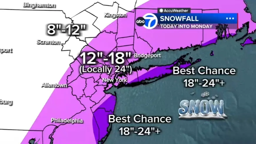
Forecast maps show widespread 12–18 inches across much of the region, with localized 18–24+ inch amounts possible in eastern Long Island, the South Shore of Nassau County and parts of the Jersey Shore. Farther north and west, where the storm's moisture will be less concentrated, totals are expected to be under 12 inches in counties such as Pike and Sullivan. Embedded snow bands are expected to produce 2–3 inch-per-hour snowfall rates; any location stuck under a band for several hours could rack up totals near two feet or more, and the most intense snowfall is likely from midnight through daybreak Monday.
Wind Gusts, Power Outages and Coastal Flooding on Long Island and Jersey Shore
Strong winds will accompany heavy snow, with gusts of 50 to 60 mph especially along the coast. Those gusts, combined with heavy, wet snow, raise the risk of power outages as trees and wires become burdened. Coastal flooding is a significant threat along the South Shore of Long Island and the Jersey Shore; vulnerable back-bay areas could see 2 to 3 feet of inundation during high tide.
Inland Communities and Blizzard Criteria
To qualify as a blizzard, conditions must include gusts over 35 mph, heavy snow and visibility under a quarter-mile for at least three hours. Many parts of the region — including inland communities such as Sussex, Poughkeepsie and Newburgh — are likely to meet or exceed that threshold tonight into Monday. Some coastal communities may face 12 to 16 consecutive hours of blizzard conditions.
Storm Organization, Timing and What Comes Next
The system is organizing and intensifying dramatically tonight, with futurecasts showing widespread heavy snow by early evening and the most intense bands from midnight into Monday morning. Two primary snowfall bands are expected to develop: one stretching from New Jersey into the Hudson Valley and another from Long Island down to the Jersey Shore. Snow should continue through Monday morning, remaining heavy at times—especially from the city eastward—before easing midday and tapering to lighter bursts by late afternoon and evening, though winds are expected to remain strong well into Monday.
Eyewitness News is providing live updates as conditions evolve. What makes this notable is the convergence of an all-county warning not seen since 1996, an upper-air pattern resembling 1978, and the potential for prolonged, high-end snowfall rates that could produce localized totals well above forecast averages.