


Fire Weather Watch expands across Plains and Rockies ahead of gusty, dry midweek conditions
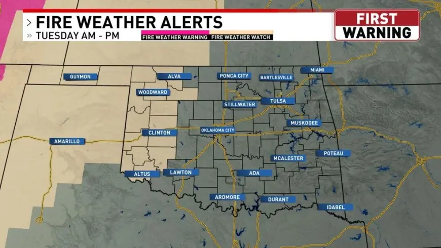
Fire managers and residents across parts of the central U.S. are facing a familiar late-winter setup: strong winds, very low humidity, and dry fuels lining up over several states. A wave of Fire Weather Watches posted Monday, Feb. 16, 2026 (ET) highlights elevated wildfire potential into Tuesday and Wednesday, with some areas already upgraded to Red Flag Warnings.
The near-term concern is not just ignition, but rapid spread—the kind of day when a grass fire can outrun initial response if it starts in open country or near roads and powerlines.
Where Fire Weather Watches are posted
Multiple regions are under watch conditions as the wind and humidity corridor shifts east:
| Area | Timing (ET) | Main risk factors |
|---|---|---|
| Northeast Kansas (including the Topeka area) | Tuesday afternoon and evening | South winds 20–30 mph, gusts up to 45 mph; humidity as low as 25%; highs in the 70s |
| Eastern Nebraska (Omaha/Valley region) | Tuesday 1–9 p.m. | Gusts 25–40 mph; humidity 15%–30%; rapid fire spread potential |
| Southern Colorado (Pueblo region) | Wednesday daytime | Very low humidity (around 10%–15%) with strong southwest winds and gusts up to 50 mph |
Conditions can change quickly. In several setups like this, watches are upgraded to warnings as confidence increases and the most dangerous overlap of wind and dryness tightens.
What a Fire Weather Watch means
A Fire Weather Watch is an early alert that critical fire weather conditions are possible, generally in the next 12 to 72 hours. It’s one step below a Red Flag Warning, which is used when dangerous fire-spread conditions are occurring or expected soon with higher confidence.
Because criteria vary by region, the practical meaning is consistent: when you see a watch, plan for a period when any spark can become a fast-moving fire, especially in grasslands and areas with dry brush.
The Tuesday setup: Kansas and Nebraska in the hot zone
In Kansas, watch conditions focus on portions of north-central, east-central, and northeast areas. Forecast details point to a classic Plains fire day: warm temperatures, southerly wind, and humidity dipping into the 20s during peak heating. That combination is particularly risky for cured grasses, which can carry fire rapidly even outside the typical summer season.
Farther north, parts of eastern Nebraska are looking at extreme fire danger Tuesday, with an overlapping mix of 25–40 mph gusts and 15%–30% humidity. The highest risk window is expected to fall in the afternoon and early evening, when humidity bottoms out and winds remain strong.
If fires start during that window, the biggest operational challenge is simple math: spread rates can outpace access, especially in rural areas with limited road networks or where fire breaks are scarce.
Colorado’s midweek wind: when watches turn into warnings
Southern Colorado is also in a volatile pattern, with very low humidity (around 10%–15%) and a ramp-up in wind potential. In the Pueblo region, strong southwest winds are forecast to peak midweek, with gusts potentially reaching 50 mph on Wednesday. The area also has a separate period of stronger winds Tuesday, with gusts possibly higher, increasing the likelihood that fire weather alerts will shift categories if the driest air arrives on schedule.
This is the kind of pattern where small ignitions—roadside sparks, debris burning, equipment use—can become incidents quickly. It’s also the kind of day when fire behavior can be erratic if winds shift or channel through terrain gaps.
What people can do now
Fire Weather Watches are as much about prevention as response. The most effective actions are the simplest:
-
Avoid outdoor burning and postpone activities that throw sparks (grinding, welding, mowing dry grass).
-
Secure tow chains and check trailer safety; roadside sparks are a common ignition source on windy days.
-
Use extra caution with cigarettes and dispose of them properly—wind can carry embers into grass.
-
Have water and tools ready on rural properties, but prioritize early reporting over trying to chase a fast-moving flame.
What to watch over the next 24–48 hours
The key question is whether forecasts tighten into the “worst overlap” scenario: peak gusts arriving at the same time as the lowest humidity. If that overlap becomes more certain, watches may be upgraded—especially for Tuesday afternoon across the Plains and Wednesday in parts of southern Colorado.
Even if alerts don’t escalate everywhere, the message is the same: during a Fire Weather Watch, it takes less than usual for a small ignition to become a large problem, and it can happen fast.