


Jersey Shore Braces for High Winds, Flooding as Weekend Storm Shifts
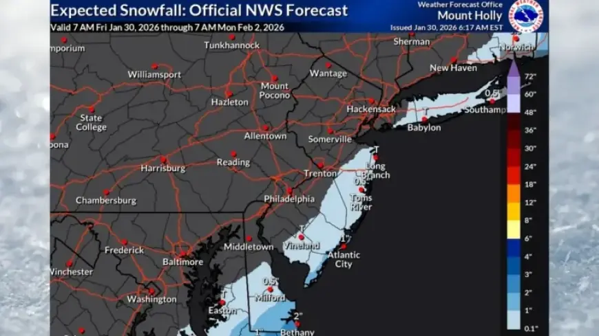
As New Jersey braces for adverse weather this weekend, a powerful coastal storm threatens the Jersey Shore with high winds and flooding. The National Weather Service (NWS) has adjusted snowfall predictions, indicating 1 to 2 inches is likely for areas near the coast, while counties further inland may see only a light dusting. This shift means that the greatest impacts will revolve around wind and coastal flooding rather than heavy snowfall.
Jersey Shore Prepared for High Winds and Coastal Flooding
The Jersey Shore is expected to experience gusts reaching up to 45 mph. Despite the revised snow forecasts, authorities are cautioning residents about potential minor coastal flooding, especially along the beaches. Moderate flooding risks are also present in the Delaware Bay area.
Impact of Ice on Flooding Risks
- The presence of developing ice on local bays complicates flooding risk.
- Higher tides from the storm could interact adversely with existing ice conditions.
The NWS has noted three main factors to monitor: high winds, coastal flooding, and light snow. Though snow accumulation is expected to be minimal, residents along the coast should remain vigilant against flooding, as further complications from ice may exacerbate the situation.
Cold Weather Advisory Extended
In conjunction with the storm, dangerously low temperatures are also an ongoing concern. Cold weather advisories for all 21 counties in New Jersey have been extended through 10 a.m. Saturday. Expect temperatures to hover around the low 20s, with nighttime lows plunging into the single digits.
- Wind chills may dip below zero, presenting risks for outdoor activities.
- Friday is predicted to be the coldest day during this current cold spell.
Future Weather Outlook
Looking ahead, next week could bring a low-pressure system to the area that might deliver additional snowfall, although the track remains uncertain. Current forecasts suggest a 20% to 40% chance of snow.
Residents should prepare for the possibility of below-freezing temperatures persisting through the next week. This pattern could extend New Jersey’s cold streak to two weeks, ranking among the top five longest stretches of freezing temperatures for numerous climate sites.
The potential for record-breaking low temperatures exists, particularly on Friday and Saturday, although it’s unclear whether all temperature records will be challenged. With the storm approaching and cold conditions persisting, residents are urged to stay updated through local weather advisories from Filmogaz.com.