


Bomb Cyclone 2026: A Weekend Nor’easter Targets the East Coast While the Gulf Coast Braces for Wind and a Sudden Freeze
Meteorologists are tracking a rapidly strengthening winter storm expected to organize off the Southeast coast and intensify into a powerful nor’easter this weekend, bringing a mix of heavy snow, damaging wind, and coastal flooding threats from parts of the Carolinas into coastal New England. At the same time, a sharp cold blast is set to spill into the Gulf Coast states, raising the odds of hard freezes, dangerous wind chills, and travel disruptions well outside the typical snow belt.
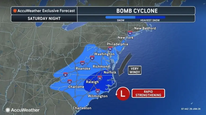
The timing is tight: the worst impacts are most likely from late Saturday, January 31, 2026 ET into Sunday, February 1, 2026 ET, with lingering snow and wind continuing into Sunday night in some areas.
What is a bomb cyclone
A “bomb cyclone” is not a separate type of storm. It’s a label for how fast a storm intensifies.
A storm earns the “bomb” label when its central air pressure drops very quickly over a short period, a process called bombogenesis. The commonly cited benchmark is a drop of about 24 millibars in 24 hours, though the exact threshold varies with latitude. When that pressure falls rapidly, the storm’s wind field typically expands and strengthens, and the weather around it can deteriorate quickly: heavier precipitation bands, stronger gusts, rougher seas, and greater coastal surge risk.
A nor’easter, by contrast, is defined by geography and wind direction: a coastal storm along the US East Coast whose winds often blow in from the northeast. A weekend storm can be both a nor’easter and a bomb cyclone if it intensifies fast enough offshore.
Weekend storm forecast: where snow and wind look most likely
The current setup favors a coastal storm that deepens as it moves northeast along the Atlantic, pulling in ocean moisture while tapping very cold air over land. That combination is what turns “a messy winter day” into a higher-end event: snow rates can spike, visibility can crash, and winds can become the story even where snowfall totals are modest.
Areas most likely to see impactful snow and difficult travel include:
-
Portions of the Carolinas into southeast Virginia, where snow bands could set up quickly and road conditions can deteriorate fast
-
Coastal sections of southern New England, where heavier snow and strong winds can overlap
-
Parts of the Mid-Atlantic coast, where the mix of wind, coastal flooding, and bursts of snow could disrupt weekend plans even if totals vary block by block
City-by-city snapshots show how quickly this could turn wintry:
-
Norfolk is currently trending toward intermittent snow Saturday with additional snow Sunday morning, totaling roughly 2 to 5 inches in many scenarios, paired with strong winds and very cold air.
-
Boston is trending toward a more substantial Sunday snow, on the order of about 4 to 6 inches, with wind that can make it feel more like a blizzard at times than a “normal” snowfall.
A key forecast challenge is the storm’s exact track offshore. A shift of even 50 to 100 miles can relocate the heaviest snow band and dramatically change totals for major population centers. That’s why some places may see mainly bitter wind and flurries while others see a plowable snowfall.
Gulf Coast of the United States: cold is the headline, not snow
Along the Gulf Coast, the weekend story is less about a classic snowstorm and more about a hard-edged cold push behind the front.
Forecasts call for:
-
Increasing wind and some rain Friday, January 30, 2026 ET
-
A sharp temperature drop late Friday night into Saturday
-
Very windy, much colder conditions Saturday, January 31, 2026 ET
Examples of how abrupt the change looks:
-
New Orleans is forecast to plunge from a rainy, windy Friday into a sunny but much colder Saturday, with highs around the upper 30s and lows in the mid 20s.
-
Mobile is forecast to turn windy and cold Saturday with a low near the upper teens.
-
Houston is forecast to run breezy and colder Saturday with a low near 30.
For families and businesses, the practical risks are familiar and costly: frozen pipes, stressed power demand, vulnerable pets and livestock, and dangerous exposure for anyone working outdoors. Even without widespread snow, wind plus cold can quickly become a health hazard.
Behind the headline: why this storm setup gets dangerous fast
This pattern has two amplifiers.
First, cold air is already entrenched across much of the East, so precipitation that falls can more easily become snow or ice. Second, ocean warmth off the Southeast coast can provide extra moisture and energy. When a storm “locks in” on that contrast between cold land air and warmer coastal waters, intensification can accelerate, and the wind field can grow.
That’s why the same system can produce very different problems across regions:
-
Inland: snowfall and low visibility
-
Along the coast: wind damage, beach erosion, and flooding during high tide cycles
-
Farther south and west: freeze impacts and dangerous wind chills
What we still don’t know
Several pieces will determine whether this becomes a disruptive weekend for tens of millions or a more localized event:
-
The storm track: closer to shore usually increases snow and wind impacts inland, farther offshore can spare big cities but worsen marine and coastal conditions
-
Snow band placement: the heaviest snow often falls in narrow corridors that are hard to pin down far in advance
-
The rain-snow line: small temperature differences can flip totals dramatically near the coast
-
How quickly the storm deepens: faster deepening tends to mean stronger winds and more intense precipitation bursts
What happens next: scenarios and triggers to watch
-
High-impact coastal event
Trigger: the low deepens rapidly and tracks close enough to drive heavy snow into coastal population centers. -
Offshore “wind and coastal flooding” dominant storm
Trigger: the low bombs out farther offshore, shifting the heaviest snow away from major inland corridors while still producing damaging coastal winds and surge. -
Southeast surprise snow pockets
Trigger: colder air arrives a few hours earlier than expected, allowing accumulating snow farther south than typical. -
Gulf Coast freeze becomes the main disruption story
Trigger: stronger winds and clearer skies maximize overnight cooling, expanding the footprint of hard freezes and pipe-burst risk.
Snow next weekend: what to expect beyond February 4
Beyond Wednesday, February 4, 2026 ET, forecast confidence drops. Pattern signals can hint at another cold shot or another storm window, but it’s too soon to treat “snow next weekend” as a lock in any specific city. The smart move is to watch whether cold air reloads behind this system and whether another coastal low forms along the same temperature boundary.
For now, the bottom line is immediate: plan for a fast-changing weekend along the East Coast, and treat the Gulf Coast cold surge as a real hazard even if snow never shows up in your backyard.