


Magnitude 4.9 Earthquake Strikes Northwest of Kalamansig, Philippines
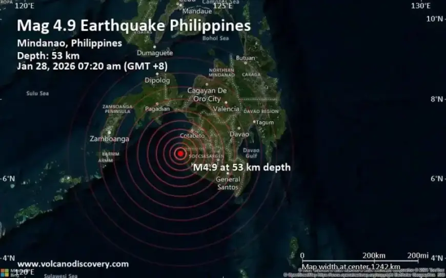
An earthquake registering a magnitude of 4.9 struck northwest of Kalamansig, Philippines, on January 28, 2026. The temblor occurred 17 kilometers from the town at a depth of 53 kilometers, according to Indonesia’s Meteorology, Climatology, and Geophysical Agency.
Details of the Earthquake
The earthquake was recorded at 7:20 AM local time (GMT +8). Initial reports confirm that the quake may not have caused significant damage but was felt as light vibrations by residents in nearby areas.
Seismic Reports
- Magnitude: 4.9
- Depth: 53 km
- Epicenter: 6.64°N, 123.93°E
- Location: Northwest of Kalamansig, Sultan Kudarat, Soccsksargen
- Time: January 28, 2026, at 7:20 AM local time
Alternate seismic readings from various agencies report slightly different magnitudes. The German Research Centre for Geosciences (GFZ) recorded it at 4.8, while the citizen-seismograph network of RaspberryShake listed it as 4.6.
Areas Affected
Weak shaking from the quake was probably felt in several nearby towns:
- Taguisa (13 km away, population: 3,100)
- Kalamansig (17 km away, population: 52,300)
- Dinaig (66 km away, population: 116,800)
- Isulan (75 km away, population: 101,500)
- Tacurong (83 km away, population: 116,900)
- Malingao (84 km away, population: 1,122,000)
- Budta (84 km away, population: 1,273,700)
- Midsayap (90 km away, population: 117,400)
- Koronadal (102 km away, population: 201,800)
No reports indicate significant structural damage, although residents felt minor vibrations. Seismologists will continue to monitor the situation, and updates may be released as more data becomes available.
If you felt the earthquake, consider reporting your experience to help provide valuable data. For real-time updates and information on seismic activities, visit Filmogaz.com.