


Major Winter Storm: Latest Updates for First Alert Weather Day
Kentucky is bracing for a major winter storm expected to bring significant snow, ice, and frigid temperatures across the state. A Winter Storm Warning is in effect until early Monday morning, as a potent system moves through the region.
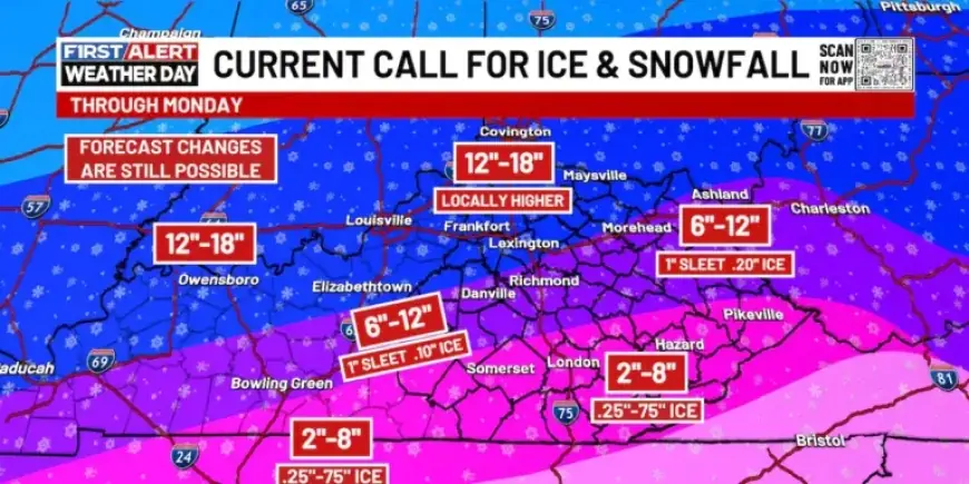
Major Winter Storm Overview
This impending storm combines heavy snow, sleet, and freezing rain, leading to hazardous travel conditions, potential power outages, and dangerously low temperatures through early next week.
Today: Bitter Cold and Snow
- Morning temperatures are expected to be brutally cold.
- Wind chills may plummet to near -10°F, prompting a Cold Weather Advisory.
- Light to moderate snow is forecasted to spread from western to southern Kentucky.
Throughout the afternoon, heavy snowfall will likely blanket much of the Commonwealth. With temperatures in the teens, this snow will be dry and powdery, potentially accumulating several inches rapidly.
Tonight: Intensifying Conditions
Snow will continue across Kentucky, with additional heavy bursts overnight. Regions that remain entirely snow will see significant accumulations, while southern Kentucky will begin experiencing sleet and freezing rain.
The northward extent of the ice line is still uncertain, but areas affected by ice could face tree damage and power outages.
Sunday: Critical Snow and Ice Threat
- Heavy snowfall will persist in northern Kentucky.
- Freezing rain and sleet will become widespread in southern and eastern regions.
The potential for ice has increased, particularly in the eastern half of the state. This period will be crucial for monitoring power outages and perilous travel conditions. Snow totals could reach double digits in areas receiving only snow.
Sunday Night: Transition to Extreme Cold
As the storm begins to taper off, lighter snow and flurries are expected overnight. However, the temperature dip will be sharp, with lows falling below zero by Monday morning, resulting in wind chills between -10°F and -15°F.
Monday: Remaining Frigid
Monday will feature scattered flurries, but the primary concern will be the extreme cold. High temperatures may struggle to reach single digits, and another subzero night is anticipated.
Wind chills could drop dangerously low, reaching -20°F to -25°F by early Tuesday morning. Such conditions necessitate precautions for anyone venturing outside.
Stay updated with Filmogaz.com for the latest weather developments throughout this major winter storm.